2015-08-28 52 1
| Fri 28 Aug 2015 in Norwich, UK: 52.5759198, 1.0423219 geohashing.info google osm bing/os kml crox |
Location
In a field between Hackford Marsh and Wicklewood Mere, Norfolk, UK. It sounds damp.
Participants
Plans
Expedition two of two spanning midnight - 2015-08-27 52 1 - 2015-08-28 52 1 - ETA 00:00.
Expedition
It was damp under foot. In bright moon light, there was a grassy lane leading to fields. There was an electric fence and sheep could be heard but none were in this field. After a bit of wandering around a route across a drainage ditch was located. This led into the marsh and the Stupidity distance began. There were tall reeds and hemp-agrimony (Eupatorium cannabinum) growing, chest high, in mud that could have been under water in the winter. The hemp is not related to cannabis. Today the marsh was damp but not too messy. The vegetation was very wet from rain earlier in the day. It was a bit of a fight through the tall reeds. The destination was on the border between the reed bed and low dense woodland. At the 5 metre mark I decided that was good enough and stopped fighting my way through. The return was a bit easier. There were six electric fence limbo manoeuvres. There was no 3G reception at this site.
Photos

The hashpoint
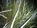
Marsh Land
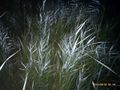
Marsh Land
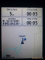
Proof
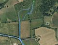
Track in Google Earth


Achievements
Sourcerer earned the Midnight Geohash achievement
|
Expeditions and Plans
| 2015-08-28 | ||
|---|---|---|
| Budapest, Hungary | Codae, Abel | In a field in Óbuda, Budapest, Hungary. |
| Stuttgart, Germany | Klaus | northwest of Bebenhausen in Schönbuch |
| Norwich, United Kingdom | Sourcerer | In a field between Hackford Marsh and Wicklewood Mere, Norfolk, UK. It soun... |
| Słupsk, Poland | Klucken | Somewhere in the middle forest. |
Sourcerer's Expedition Links
2015-08-27 52 1 - 2015-08-28 52 1 - 2015-08-30 52 1 - KML file download of Sourcerer's expeditions for use with Google Earth.