2015-09-20 49 9
| Sun 20 Sep 2015 in 49,9: 49.8488893, 9.9247735 geohashing.info google osm bing/os kml crox |
Location
On a quite steep field near a collection of trees which weren't quite numerous enough to be called forest.
Participants
Plans
I noticed the point was relatively near to a route I could use on my way back home from a friend so i decided to stop there and see where things go.
Expedition
This time round I set my self the goal of finally doing a tron route. I defined my starting point in Gadheim and also set myself the challenge to not only not cross my own path, but to not stop on the way (not even at the hashpoint). It was therefore really hard to take pictures of the interesting landscape and the hashpoint itself without blurring them. The walk there was relatively uneventful apart from two fawns there and some art installations. Nearing the target point, I had to leave the farm tracks and steer towards the target hoping to hit the right destination and thus not needing to return, which worked far better than I had anticipated and I crossed the hashpoint within my GPS accuracy. Shortly afterwards I started worrying as a crossing in the copse ahead of me didn't appear to be there as the mapview had suggested, but just as I had readied myself to return and thus invalidate my tron attempt, the quite hidden opening emerged where it was supposed to be and I could return back to my starting point without stopping.
Tracklog
Available on request. Or just look at the pictures below.
Photos
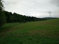
Shaky picture somewhere in the general area of Gadheim
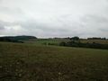
nearing the hashpoint
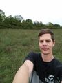
stupid grin™ shortly after the point
Proof
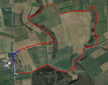
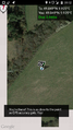
Path taken; the blue bits are filled in manually afterwards, as the recording got cropped.


Achievements
Gefrierbrand earned the Land geohash achievement
|
Gefrierbrand earned the Two to the N achievement
|
Gefrierbrand earned the Tron achievement
|