2015-09-26 46 -116
| Sat 26 Sep 2015 in Lewiston: 46.0737960, -116.9585734 geohashing.info google osm bing/os kml crox |
Location
Just east of Rogersburg WA on the banks of the Snake River.
Participants
Plans
Early afternoon visit, after driving across the state.
Expedition
Addicted to geohashing, check. My plan is to geohash the entire state of Washington, and this little sliver sits a long ways from my home in Seattle. Fortunately, a friend was celebrating his 50th birthday 120 miles west of here, and I would be a surprise guest. I was also traveling solo, as my wife and kids had other plans. So, as they say, the stars aligned...
GPS had me on Highway 12 for much of the route, which I had only traveled in smaller chunks before. Like other expeditions before, I found a Spud to stop at for a pre-hash bite.
Turning south from Clarkston, the last major population center is Asotin. Rogersburg is listed as a ghost town in some places, but not the fun abandoned-buildings-in-the-wild-west ghost town. Just a place that used to have a post office but no longer does. More on that shortly.
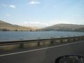
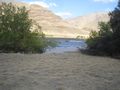
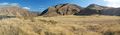
The hills rose on both sides, and further up river was Hell's Canyon. The Snake river separates the lower part of Washington and the upper part of Oregon from Idaho, and it's meanderings mean that this was the easternmost portion of Washington State.
Another curious thing I found on the way is that the lazy GPS map programmer decided he had drawn enough blue river. The border between the states continued, though.
The pavement did not. At several points along the way I passed signs claiming that the road narrowed - now it reached a two-lane dirt format. Washboards too, of course. Continuing a bit further, I crossed a bridge and found only a one-lane road on the other side. Still plenty of washboards.
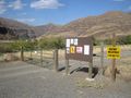
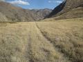
A gate blocked the road in the area of Rogersburg, so I parked and walked. Trespass was not prohibited, and this area gets plenty of traffic during fishing season. Rogersburg is now a collection of 15 or so houses. Reaching the other end of town, I found another gate prohibiting motor vehicles. Beyond this, the road narrowed yet again, to a double path.
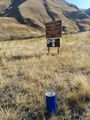
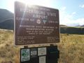
Ahead lay the airport, at least according to the maps. I doubted I would find pavement, and did not. Instead, a dirt airstrip and cylindrical reflectors marked the end of the runway and lined it in white. At approximately the center, I found a sign giving airport details and a log book - last signed in on Sept 15 of this year. Yes, this geohash would be far more easily reached by Robyn than me. I did not sign the guest book, as this was not an aviation activity.
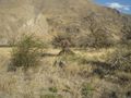
After traveling 1471 feet along the runway, I turned off towards the hashpoint itself. It lay on a low portion of land, likely an island in high water conditions (and underwater in higher conditions). No animals were directly in evidence, though there were a lot of small holes in the ground. I kept a vigilant eye out for snakes.
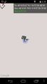
Reaching a clump of rocks, I found the GPS close indeed. Meters of wandering west and north failed to lock in a closer signal, so I screen captured the best bet. I also snapped a few more photos and began the long trek back to civilization.
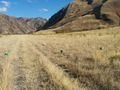
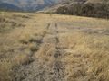
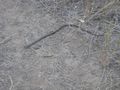
The first thing I noticed on this sometime island were evenly spaced tracks. An ATV, perhaps, in this no-motor-vehicle area? As the road again grew to eventual normalcy, I also passed a little greenish snake in the road. Quite appropriate to the nearby river, I snapped his picture for the log here.
I then headed out to meet my friend, missing dinner but still enjoying much of the fun - and cake. Was it worth the trip? Definitely. Will I ever return? Quite unlikely. I am now 16/29ths through with my home state.
Tracklog
Photos
Spud!
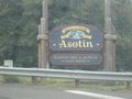
Civilization
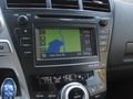
Lazy coder
North by Northwest, sans corn

Idaho and Washington


Achievements
Thomcat earned the Graticule Unlocked Achievement
|