2015-10-15 52 1
| Thu 15 Oct 2015 in Norwich, UK: 52.3408065, 1.2076073 geohashing.info google osm bing/os kml crox |
Location
1) In a pasture north of Cross Street, Suffolk, UK.
Participants
Plans
Expedition one of six spanning midnight. It's not obvious how to reach this point and the chances of success are lower than usual.
2015-10-15 52 1 - 2015-10-15 52 0 - 2015-10-15 52 -0 - 2015-10-16 52 -0 - 2015-10-16 52 0 - 2015-10-16 52 1 - ETA 21:15.
Expedition - Fail
There was a public footpath leading to fields. A field perimeter led in the right direction. Close to the point, there was a ditch and a well maintained hedge. About 19 metres from the destination this first attempt was abandoned. Two other potential routes were tried. New houses had been built bordering the pasture. Here there was a top grade fence with a parallel electric fence. The final possibility to the east was gated. The pasture was for well looked after horses and very well protected.
Photos
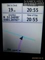
Fail. @52.3410,1.2077
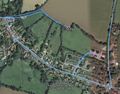
Track in Google Earth


Achievements
Expeditions and Plans
| 2015-10-15 | ||
|---|---|---|
| Northampton, United Kingdom | Sourcerer | 3) On the A14/A141 roundabout, Huntingdon, Cambridgeshire, UK. |
| Cambridge, United Kingdom | Sourcerer | 2) In a field south of Stretham, Cambridgeshire, UK. |
| Norwich, United Kingdom | Sourcerer | 1) In a pasture north of Cross Street, Suffolk, UK. |
Sourcerer's Expedition Links
2015-10-14 52 0 - 2015-10-15 52 1 - 2015-10-15 52 0 - KML file download of Sourcerer's expeditions for use with Google Earth.