2015-10-17 52 0
| Sat 17 Oct 2015 in Cambridge, UK: 52.8748105, 0.4796840 geohashing.info google osm bing/os kml crox |
Location
In the middle of Snettisham Common, near the coast of The Wash
Participants
- PaintedJaguar
- MrsPaintedJaguar
Plans
Looking to do a short walk in the area around the hashpoint, but can't make the standard 4pm meetup time. The plan will be:
- 15:35 train from Cambridge to King's Lynn, arrving at 16:21 (remarkably cheap at £4.95 for a railcard discuounted return ticket)
- 16:30 bus (number 10) from King's Lynn to Snettisham, arriving at 17:08 (am willing to bet that this will cost more than the train!)
which leaves ~50 minutes before sunset at 18:00, or maybe 1.25 hours before it's dark. The planned walk claims that it will take 1.5 hours to do 2.6 miles, which is quite a slow pace - 1.5 hours including the diversion to the hashpoint seems more likely. With the last part on residential roads, darkness shouldn't be a problem. Even so, to have a little bit more light for the coastal views, we'll do the walk in reverse, and will therefore be visiting the hashpoint on the way back inland, maybe at about 18:00.
A meal may then be had at a pub in Snettisham; 20:50 is the time of the last bus that still allows a connection with a train back to Cambridge.
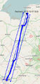
Double-checking the map just before setting out suggests there is a possibility of claiming a Juggernaut achievement on this expedition, but we've not left enough time to plan it in detail, so we'll just record the entire tracklog and check afterwards!
Expedition
In terms of logistics, this was a very uneventful expedition that went exactly as planned.
The bus fare, for the record, was £4.35 each for a return, so slightly cheaper than the train ticket, but this was a special "two people must travel together" ticket, so maybe a lone return might have been more than the train ticket!
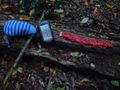
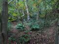
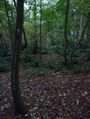
The walk itself was a pleasant woodland walk, easily completed during twilight and we were safely in the Rose and Crown, ordering what turned out to be a delicious meal, before 18:30. Some makeshift swings in the woodland provided a temporary diversion just before we got to the hashpoint. Actually finding the hashpoint was slightly tricky, and an interesting lesson in how much accuracy GPS receivers lose under cover of trees. We were able to walk several metres in all directions without the GPS updating its display of how close we were at all, though eventually we did get it down to just 2 feet away from the hashpoint (albeit with an accuracy of 48 feet, so who knows how close we really were!) We left a chalk marker on a nearby tree, and back at the point where we deviated from the path to reach the hashpoint, we left a further marker pointing into the woodland.
One lesson we need to remember for future expeditions is not to assume that the weather 50 miles away will be the same as at home! A grey and overcast, but dry, forecast for Cambridge turned out, in Snettisham, to be the horrible kind of persistent drizzle that completely soaks you without you realising just how wet it really is. Fortunately since most of the walk was under the cover of trees, we got away without getting too wet until the last half-mile or so back to the pub.
Back home, we did the Juggernaut calculations, and checked them against our tracklog, which showed that we'd successfully managed a Juggernaut expedition without even trying (exact calculation: straight line distance = 79km, maximum deviation from straight line = 2.7km (just North of Ely station), ratio = 1:29).
OpenStreetMap also turned out to be missing the path (actually a bridleway on OS maps) alongside Snettisham Common, effectively a straight line from alongside the hashpoint to the nearby main road, so updating this allowed another achievement to be claimed.
Tracklog
http://www.wikiloc.com/wikiloc/view.do?id=11128174 shows the walk from Snettisham, or see the photos below for the full journey and juggernaut boundary.
Photos
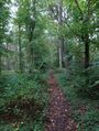
Pleasant woodland walking
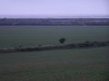
There's a view of the sea out there somewhere, honest!
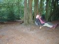
A short delay to the expedition
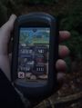
Success!
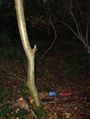
Chalk marker left on tree
Hashscots

Silly grins
"View" from the hashpoint
Chalk marker pointing towards the hashpoint from the main path
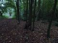
The path near the hashpoint
Juggernaut proof


Achievements
PaintedJaguar earned the OpenStreetMap achievement
|
PaintedJaguar earned the Juggernaut achievement
|