2015-10-19 52 1
From Geohashing
| Mon 19 Oct 2015 in Norwich, UK: 52.5751203, 1.0535245 geohashing.info google osm bing/os kml crox |
Location
In a field south of Wicklewood, Norfolk, UK.
Participants
Plans
Expedition one of two spanning midnight - 2015-10-19 52 1 - 2015-10-20 52 1 - ETA 22:50.
Expedition
- Arrived. -- Sourcerer (talk) @52.5750,1.0535 22:48, 19 October 2015 (GMT+01:00)
This went to plan. There was a good place to park and a tractor width access route led round the perimeter of the sugar beet field. The closest approach without treading on the plants was 8 metres. Good enough.
Someone seemed to be joy-riding a tractor trailer combination. This was roaring up and down the lanes and farm access roads without apparent rhyme or reason. That was the scariest thing on this pair of expeditions.
Photos
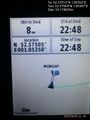
Proof. @52.5750,1.0535
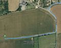
Track in Google Earth


Achievements
Expeditions and Plans
| 2015-10-19 | ||
|---|---|---|
| Coastal Plains, Australia | Felix Dance | Inside a peach orchard near Humpty Doo. |
| Stuttgart, Germany | Klaus | northwest of Bebenhausen in Schönbuch (again!) |
| Norwich, United Kingdom | Sourcerer | In a field south of Wicklewood, Norfolk, UK. |
| Słupsk, Poland | Klucken | A forest between the villages named Objazda and Karżcino. |
Sourcerer's Expedition Links
2015-10-16 52 1 - 2015-10-19 52 1 - 2015-10-20 52 1 - KML file download of Sourcerer's expeditions for use with Google Earth.