2015-10-20 43 -78
| Tue 20 Oct 2015 in 43,-78: 43.0184055, -78.9204157 geohashing.info google osm bing/os kml crox |
Contents
[hide]Location
Grand Island, NY next to Spicer Creek in a subdivision
Participants
Plans
This will be my first attempt on Grand Island which is also the location for the corner of 43.0, -79.0. I will hopefully get the first hash for my Regional achievement for Grand Island, but this section of Grand Island that is part of the Lockport Graticule is the largest and most likely to be hit. The other three graticules have a much smaller section of the Island; Especially the Dunkirk Graticule which only has a tiny corner.
Also to note, this will be my 64th expedition for a level 6 in the 2 to the N achievement.
Expedition
Made it out to Grand Island without too much trouble after work. Paid my toll at the bridge and found the house by the hash. I parked by the creek that was close to the hash and started to follow the GPS.
I first tried the edge of the mulched area by the tree in the picture below, but the GPS still said about 20 feet to go. I was a little worried because the ground in front of me was pretty wet and I thought swampy. I went around that spot and found firm ground, so I pushed on. I found a little clearing in the bushes and got a close reading. I figured with the heavy clouds and being in thicker woods, this was the best I was going to get.
I attempted to get pictures, but the flash was problematic and when that wasn't an issue, it was the focus. Finally getting something decent, I made my way back to the car and drove to my parents for a little visit since they were sort of on the way home.
Photos
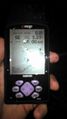
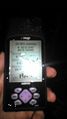
Sorry for the blurry pictures. My camera phone did not do well in the evening light.
Made it.
Accuracy.

At the hash.
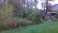
The hash is in the bushes about 20 feet.


Ribbons
This user earned the Land geohash achievement
|
Pedalpusher earned the Two to the N achievement
|