2015-12-17 39 -89
| Thu 17 Dec 2015 in 39,-89: 39.8200273, -89.6973881 geohashing.info google osm bing/os kml crox |
Location
A field just off Veterans Parkway in Springfield.
Participants
Plans
Drive out there around noon.
Expedition


After months of geohashes on the other side of the graticule, finally one is stupidly close to home! Dolphintreasure and I were originally planning to spend the day cleaning ahead of the holidays, but obviously geohashing takes priority! We grabbed our two hash-foxes, got into our new hash-car (purchased in August), and set out for our random mid-day adventure.
The road that the point was closest to was Veterans Parkway, a major divided highway and one of the highest trafficked roads in Springfield. We decided it would be best to turn off onto Winch Lane and park the car on a gravelly bit where an old railroad line had once gone through at some point in the past. Much of the old line has been converted to a bike trail, but this section was not, and had a bright yellow gate across it. It was decided that "bright yellow gate" is probably a synonym for "No Trespassing", especially considering the over-abundance of such signs in the backyard of the house directly adjacent to the gate. This was a conundrum, because the old rail line was the easiest way to head to the hash point. Without that route open to us, we would have to head cross country the whole way, through all manner of dormant plant life.
We made our way down Winch Lane until we found a break in the foliage. At this spot was what was apparently a way to drive into the field, with a steel cable running across it and a big "No Dumping" sign. It didn't say we couldn't enter, so we did. There was all manner of broken bricks and concrete laying around, which made us giggle at the uselessness of the sign. As we navigated our way through the trees and brush, we eventually came to a sizable prairie. Looking across, we could see the rail line, with a person walking their dog. It seems we could have taken it after all, but too late for that! On the border of the prairie were many thorny stalks and trees, including one that had thorns longer than some of our fingers. With the hash point on the opposite side of the prairie near a tree line, we had no choice but to carefully navigate the thorny mess on our way across.
After much trudging along, avoiding wet marshy areas as we walked, we closed in on the point and took our photos. Success! We decided the easiest way back to the hash-car would be to take the rail line. Following the tree line north, we made our way closer, but came across a completely saturated area of grasses that couldn't be navigated without getting water in our shoes. Now with feet wet and cold, we hastily made our way down the trail and back to the car to head home.
Photos

Water, water everywhere, and also in our shoes!
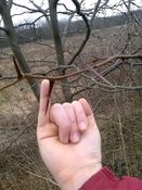
A thorn like this could probably kill you if it hits the right spot.

Mystrsyko, Dolphintreasure, and hashfoxes Collin and Todd.
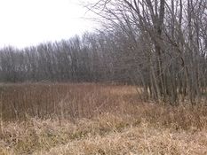
From the point looking north towards the rail line.
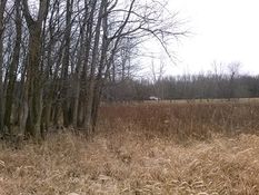
From the point looking south at Veterans Parkway.
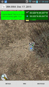
Proof!


Achievements
Mystrsyko & Dolphintreasure earned the Land geohash achievement
|
Mystrsyko earned the Two to the N achievement
|