2015-12-29 52 0
From Geohashing
| Tue 29 Dec 2015 in Cambridge, UK: 52.7548441, 0.2626942 geohashing.info google osm bing/os kml crox |
Location
2) In a field between the rivers Nene and Great Ouse, west of Kings Lynn, Norfolk, UK.
Participants
Plans
Expedition two of three spanning midnight - 2015-12-29 52 1 - 2015-12-29 52 0 - 2015-12-30 52 0 - ETA 22:35.
Expedition
The journey was more interesting than the hashpoint. The River Great Ouse was very full at high tide. There was nice moonlight. There was roadside parking by the field entrance. The walk was under 50 metres into a dry field of winter wheat. I was two minutes ahead of my planned schedule.
Photos
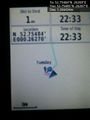
Proof of arrival. @52.7548,.2627
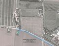
Google Earth Track


Achievements
Expeditions and Plans
| 2015-12-29 | ||
|---|---|---|
| Seattle, Washington | Benjamin Kaiser | In the trees/bushes (lots of ferns) behind a house in a seemingly quite wea... |
| Nürnberg, Germany | Breti | Huzza, my first Geohash Breti -- Breti (talk) @49.7548,11.2627 15:10, 29 ... |
| Bonn, Germany | Burgman | A meadow between Geistingen and Rott, near Hennef. |
| Cambridge, United Kingdom | Sourcerer | 2) In a field between the rivers Nene and Great Ouse, west of Kings Lynn, N... |
| Norwich, United Kingdom | Sourcerer | 1) In a field behind the church of St. Mary the Virgin and St. Botolph, sou... |
Sourcerer's Expedition Links
2015-12-29 52 1 - 2015-12-29 52 0 - 2015-12-30 52 0 - KML file download of Sourcerer's expeditions for use with Google Earth.