2016-01-03 42 -78
| Sun 3 Jan 2016 in 42,-78: 42.0336429, -78.8717493 geohashing.info google osm bing/os kml crox |
Location
Allegany State Park near the Firetower Trail
Participants
- Pedalpusher
- Simon the dog
- Myka the dog
Expedition
Seeing the hashpoint not too far from another one I went to on 2015-06-07 I figured this wouldn't be too hard. I also was excited to be hashing again after missing my first entire month without an expedition since I started.
I knew this one was further into the park than the one in June, but it would definitely be by the Firetower trail and figured I could even park at the trailhead. The only wildcard would be the snow. In the past few days we had gotten 6-8 inches(15-20 cm) of snow so I figured there would be at least double that in Allegany.
I packed up the dogs early in the morning and we were off to the park around 9:00am and arrived a bit after 10. I was pleasantly suprised to see just a dusting of snow on the ground which would definitely make things easier. Parking at the start of the trail, I started walking up the trail a bit before cutting South to the hash. I made my way along the steep ridge and found the hash area, but it took a really long GPS dance to get a decent reading. It was right by a stream and there was a lot of crossing back and forth too. I think the issue was that I kept losing and picking up different satellites. At one point, the 'distance to go' jumped up to over 400 feet before dropping back down to 50. As I was finishing snapping pictures of myself and the dogs, my phone died. I have been having issues with my phone dying lately(it's an old phone) and this was the final push to get a new one(which I ordered the next day).
Fortunately, I had my work phone with me too, so after I made it up to the trail, I took some pictures with that when I got to the abandoned fire tower. Getting up to the trail was quite hard though as the going was extremely steep. The trail follows the narrow top of the ridge and I remember hiking this trail when I was young with my family. I remember the first mile of the trail was the steepest I had ever hiked and that was not nearly as steep as what was in the middle of the trail where I was meeting it. Getting to the tower, I turned around and just followed the trail back to the car.
Now, a few days later, I am writing up the report and I told the story about the phone because today I did a very dumb thing. I received my new phone in the mail and have been getting things set up the way I want, and had transferred the micro-SD card over. Not thinking about it, I wanted to erase the data that was on there from the apps and games from the old phone. Foolishly, I formatted it without checking, and erased all my pictures from my hike. Unfortunately, my data limit was reached for the online backup, and those pictures are tragically gone forever now. At least I have the three I took with my other phone.
It's not quite a Blinded by Science as I made it to the hash, I just mucked up the technology by deleting most of my proof. Things would have also been ok had I not procrastinated with my report.
Photos
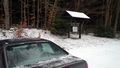
Parked at the trail for the Firetower and Mt. Tuscarora
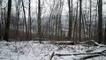
It was much clearer being there, but you are looking at the lake in the valley from the trail at the top of the ridge.
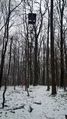
Here is the abandoned firetower where we turned around. If you look closely by the base, that pink spot is Myka's coat.


Ribbons
This user earned the Land geohash achievement
|