2016-01-03 49 7
| Sun 3 Jan 2016 in 49,7: 49.0336429, 7.8717493 geohashing.info google osm bing/os kml crox |
Location
In the french part of the Kaiserslautern-graticule, in the forest between Climbach and Wissembourg near the german border.
Participants
Plans
Hey, this is a chance to win many shiny achievements. And it's in a reasonable distance for a nice bull-ride. And I do have the time to go there. So, what could be the plan?
Go there by bull and drive home by train, of course.
Expedition
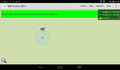
I couldn't start before 11:45 and as the weather was sunny it was quite warm (at least for early January). Especially as the wind came from the south. On the other hand that means the wind was against me most of the time. But with the support of my bull I was pretty fast and and after almost two hours I reached the french border. That means, I just ride along a footpath when suddenly the traffic signs had changed and the name of the streets wasn't "Straße" anymore but "rue". So I had a look at the map and found out that the path I came from was part of the border and that I had just entered France. I took a picture and a screenshot of the map and continued my way. Soon I reached Wissembourg, but I didn't have the time to visit this beautiful little city. Behind the town the landscape changed dramatically and I had to climb up to the Col du Pigeonnier to more than 400m. I reached the place with low (but sufficient) batterie.
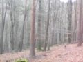
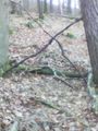
I had to leave the street and turn into the forest here. I found the right way on the second trial but after 300 m the way was to bad to continue riding. So I staked the bull a kilometer from the hash and continued my way walking. I had to go steep downwards first, then I reached a wider path and followed it for another kilometer. When I came near the hash a path branched of to my left in the hashes direction. As it wasn't mentioned on osm, I will add it for another achievement later. The hash was in a light forrest on the slope of a valley, that marks the border between France and Germany here. The usual pictures were taken and a large X as a mark was built. Then I continued my way back to my mount. The map showed a different way, so I didn't have to follow my own way back.
I returned to the Col du Pigeonnier, and enjoyed the downhill back to Wissembourg. There is a station in Wissembourg with a train back home, but the next train departed in 25 minutes and so I decided to ride to the next station back in Germany, because I'm more familiar with the german ticket machines (and the batterie did recharge enough during the downhill). From here it was just an uneventful train ride with two changes in Neustadt and in Schifferstadt. I reached home again at 5 pm.
Tracklog
76 km bullriding and 3,5 km walking and here with 71 additional km by train.
Photos
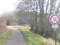
the first french sign
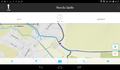
proof of the border-crossing
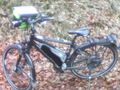
proof of transport (my bull in the forest)
50 m down there
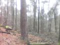
view from the hash (to the west, pretty much the same to the south and the east)
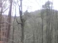
to the north you look over the valley. The slope on the other side is in Germany
sign

me, a grin and the sign
proof


Achievements
DODO earned the Land geohash achievement
|
DODO earned the Border geohash achievement
|
DODO earned the Reverse regional achievement
|
DODO earned the OpenStreetMap achievement
|