2016-02-06 42 -78
| Sat 6 Feb 2016 in 42,-78: 42.1026388, -78.7079250 geohashing.info google osm bing/os kml crox |
Contents
[hide]Location
Allegany State park, by Camp Allegany
Participants
- Pedalpusher
- Simon the dog
- Myka the dog
Plans
Great opportunity in Allegany, but too bad it's not for Sunday. There are so many options available for the 6th but for another year, my birthday, the 7th has nothing good. Anyway, enough whining about the cruelty of the algorithm...
I'm planning on leaving the house around 2-2:15 to give myself plenty of time to get there and find a place to park. I will hike into the hash which looks like it is very close to a trail and hang around for an official 4pm meetup. After that, I'll probably hike around a little bit with the dogs with the available daylight that is left.
Expedition
There was a slight change to the plans, but I was still aiming for an Official 4pm Meetup. My sister called me on Friday, asking if I wanted to go to the Buffalo Bandits(Professional Lacrosse) game in the evening on Saturday. That crunched the time I would have to hike around after getting to the hash.
I left the house a little before 2 and arrived at the Camp Allegany area a bit after 3pm. I got the dogs out of the car and we started to walk up the road and we found the trail where expected at the end of the road. I am glad we have been having a VERY mild winter so far, because I saw I would be walking on cross country ski trails and dogs or hiking are not allowed during ski times. Seeing that we only had about 0.5 inches(1.5 cm) of snow in the deepest spots and a lot of bare ground everywhere, I knew there wasn't much skiing going on and in fact, I only saw one other set of footprints on the trail.
Getting to the trail, I saw I was about a half mile(less than a KM) away, so I set my alarm to go off in 20 minutes. I figured I could walk up the trail for that long and then when it went off, I would get back to the hash right around 4pm.
Walking in on the trail, I hadn't gone far when I noticed something weird in the woods; something red/pinkish off the trail about 30 meters. I went to investigate because I wanted to know what was so brightly colored in the mostly grey winter woods. It turned out to be some fake flowers at what looked like a small memorial. I'm thinking someone's ashes were spread there and the flowers marked the spot.
Getting back to the trail, there wasn't much else to see, but it was a nice hike until my alarm went off(I'll have to come back to this area and explore further). Turning around, I flipped on my GPS and followed the trail back to the hash, which was only about 60 feet(20 meters) off the trail. Doing the hash-dance, I got within 4 feet and got some pictures. Concerned about the time schedule I needed to stick to, I forgot to grab a screenshot of the time for the official meetup, but there are time-stamps on the pictures if you go to the file page.
Hiking out of the woods, I figured I had a few minutes to spare before I needed to leave and I found where the trail and road met, there was an old Skiing hill. I decided to walk up and I'm glad I did. At the top, I found the old housing and machinery for the tow rope which was cool. The view from the top was very nice too, but I didn't have long to admire it. I needed to get going so I could get ready to meet my sister for the game later.
Another very cool expedition to an area that I probably would never have gotten to explore or seen otherwise.
Photos
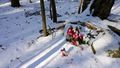
The memorial we found on the way into the hash. It was almost a random coffin-potato hash, missing by less than 1km
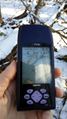
Made it for an Official Meetup, time-stamp is in the Metadata on the filepage. I forgot to grab a screenshot of the time.
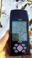
Accuracy.
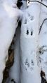
Walking up to the hash, there was evidence of a small rodent, probably a chipmunk.

Happy with another success.
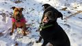
The dogs making funny faces at the hash.
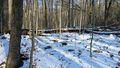
Walking back to the trail, a view to the hash.
Before getting back to the road, we decided to check out the old ski slope.
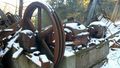
At the top, we found the machinery for the tow-rope with the building around it pretty much gone.
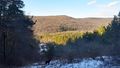
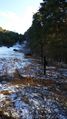
A view from the top of the slope.


Ribbons
This user earned the Land geohash achievement
|
Pedalpusher earned the xkcd Nullaturion achievement
|
Pedalpusher earned the Last man standing achievement
|
Expeditions and Plans
| 2016-02-06 | ||
|---|---|---|
| Buffalo, New York | Pedalpusher, Simon the dog, Myka the dog | Allegany State park, by Camp Allegany |