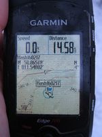
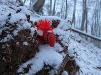
2016-02-17 50 11
| Wed 17 Feb 2016 in 50,11: 50.8651843, 11.5480214 geohashing.info google osm bing/os kml crox |
Location
About 80 meters from a path near Leutra village, south of Jena.
Participants
- Juja and Davey
Expedition
Once again, this was a Geohash that seemed too close to miss - in my head this was "practically on the way to training", but actually it was a detour of 13kms.
As soon as I declared I'd try to cycle there between work and training it started to snow - not heavily, but steadily. For hours. The roads (and paved cycleways) were still warm enough to be snow-free, so I had no problem to get to Leutra village, perfectly on time or even ahead of my plan. So I already wondered what I'd do with the spare time until training began... but of course, being back early is not a thing to be pondered while Geohashing.
It soon became Geohashing-business-as-usual: after I had passed Leutra, the road was paved no longer, but I could ride through the mud for a while, until I had to turn left to go a bit uphill. At the turn the way got worse, there were deep skidmarks all over it, now covered in snow but still too squashy to last long on a bike. An additional problem was that my tyres picked up the wet snow and lots of the leaves that were hidden under it, so I suddenly had a fatbike every few meters and nothing moved until I cleaned the mess that was stuck under the mudguards.
I eventually came to push/carry my bike the last few hundred meters until the Geohash came nearer, but at 80m distance the next challenge presented itself: I wish I was able to interpret topographic maps, but obviously I'm not, because again I had completely ignored all those contour lines that huddled between path and Geohash point. 80 meters don't seem a lot, but it is a lot when it goes so much uphill that every step is hard work. I fetched some halfway solid sticks that I could use as improvised pickaxes at the steep, slippery slope.
With a lot of huffing and puffing I finally made it, took the pictures (safely lying flat on the slope) and then I had to come up with a good idea how to get back down this mess. Because it is always a good idea to bring old plastic bags to Geohashes, I took one out of my backpack, tucked everything else safely inside, sat on the bag and sleighed down on my bottom, passing the occasional root or tree in my way and not getting hurt at all. Back down at my bike, I took the other way out, had to clean my tyres one last time, had to remove the frozen lump from the bottom tube to make the shifters work again and off I raced to my training, arriving there at the exact time when everyone else arrived by tram. I am always amazed when my planning works out like this. We won't talk about my wet clothes and the pieces of forest that suddenly were all over the changing room...
Photos
|


