2016-02-20 52 1
| Sat 20 Feb 2016 in Norwich, UK: 52.2643397, 1.3665945 geohashing.info google osm bing/os kml crox |
Location
A field corner not far from a footpath, west of Badingham, Suffolk, UK.
Participants
Expedition
Wind blown horizontal drizzle stopped against all the odds for the walk. It resumed on the car drive back home. It was over 12 C; unusually warm for the time of year. Some summer nights are colder. There was weak moonlight barely penetrating the cloud cover. The walk was muddy and on field perimeters. The hashpoint was a few paces into a very wet field. Clay clods built up under my footwear. Near the destination there was a railway sleeper bridge blocked by hedge clippings until I heaved the prickly material out of the way.
Photos
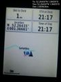
Arrival proof @52.2643,1.3666
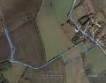
Google Earth Track


Achievements
Expeditions and Plans
| 2016-02-20 | ||
|---|---|---|
| Zürich, Switzerland | Calamus | A field near Merenschwand AG. |
| Mannheim, Germany | DODO | A muddy field near Lingenfeld. |
| Norwich, United Kingdom | Sourcerer | A field corner not far from a footpath, west of Badingham, Suffolk, UK. |
Sourcerer's Expedition Links
2016-02-13 52 1 - 2016-02-20 52 1 - 2016-02-23 52 1 - KML file download of Sourcerer's expeditions for use with Google Earth.