2016-02-29 41 -79
| Mon 29 Feb 2016 in 41,-79: 41.6202847, -79.6495077 geohashing.info google osm bing/os kml crox |
Contents
Location
In a field in an industrial park; Titusville, PA
Participants
Plans
There wasn't any good hash-points close, but this being leap-day, I wasn't sure if I wanted to wait another 4 years for this to come around again. So, I'm driving 2 hours to Titusville, PA after work! As a bonus, I'll get the XKCD-100 honorable mention(if successful, of course).
[Aw, look at all that hope and promise...so cute.]
Expedition
*Banging head on desk*
I write up this report knowing what went wrong, but I'll leave that bit to the end. Sorry for the really long write-up but I'm hoping I feel better just getting it all out...Here's how everything went down:
Driving a little over 2 hours to Titusville was mostly uneventful until I got into the town itself and missed Main St. It seems everywhere I go in PA they don't like to mark their intersections well(or at all sometimes). I drove over a bridge and saw a sign for Drake's museum (the place where oil was first struck in America) and knew I went too far. I turned around, and found my way back to Main St and to the Industrial park.
Driving over the tracks and turning Left, I found an opening in the brush on the side of the road and saw there was a gas well just down the path. It's always nice to see everything matching up with what you expect. However, this is pretty much where my excitement ended because I also saw standing water...a lot of it. It looked pretty shallow but there were tufts of grass all over so I figured I could make my way through without getting too wet.
I got through the first section of water to see more of the same (My Kingdom for a boat?). I should mention I parked just after sunset(a bit after 18:00) so I was losing all available light and had to rely on my flashlight at this point. I couldn't see much further than 20 or 30 meters and I was getting discouraged. If it was going to be like this the whole way, it was going to be really tough. From the satellite pictures, I was expecting maybe a soggy field but with a mostly solid road to walk down.
The entire time, I was thinking how out of date the satellite images must be because to both sides was the thickest brush I had ever seen and it was quite tall too. I think the only thing keeping this path clear was the truck they drove down probably only a few times a year. In this second section of water, I slipped in and it was just over ankle deep in places. With both feet soaked through and having driven for so long, I didn't care any more. I was getting to the hash. Fortunately, the land rose up a bit and I didn't have to deal with the water any longer. However, on the path, I started about 0.25 miles (400 meters) away, but I wasn't getting any closer as I was walking. Remembering the map, I just knew I had to follow the path to the hash, but I started to hear rushing water. Eventually I hit a very large creek and that was were the path ended too and my heart sank.
I knew if I could even find a way through the brush, I would be fighting for every inch as it was so thick and very likely, I would hit more standing water (My kingdom for a chain saw?...no for a TANK!). I just didn't think I would make it 25 meters let alone the .25 miles and so with sunken spirits, made it back to the car doing a better (but not perfect) job of avoiding getting more water in my boots. At the car, I took off my boots and socks, drained both as best I could and started to drive somewhere for dinner.
Now, before I left home, I saw on the map in the next town(Hydetown) a "Rustic Inn and Restaurant" and thought that would be a good place to stop. I had seen on the drive down, a bit before Hydetown, there was Gina's Restaurant that promised a home cooked style meal and after this ordeal, that seemed more appealing. Pulling into Gina's though, I saw the hours posted as closing at 19:00. It was currently 19:20 so I didn't even want to ask them if I could eat, even though I still saw people finishing up their dinners. Last place I saw on the drive down was a bar in Union City which wasn't that much further on the way home. Finding a place to park, I was surprised to see that it was a smoking establishment. Those haven't been around any more in New York State for probably around 10 years or so. With no where else to go, I walked in and was at least glad to see no one currently smoking. I also had about a half hour to spare to order food which I just got some chicken fingers.
The rest of the drive home was uneventful, but the next day, I decided to try and figure out what went wrong.
Analysis of the Situation
So the images looked the same as I zoomed in and out, but the area by the hash looked like a field that was tended to. For the growth that I saw, the satellite images would probably have to be YEARS out of date. Then I saw it...another possible path closer to where I drove in. Zooming in on that spot, I saw the gas well rigging and knew what happened. In the dark, I saw the opening and assumed it was the one going into the field and followed it with abandon not realizing I was in the wrong spot.
I'm not sure I would have had a different result had I gotten there in daylight though. From seeing the opening for the path I had already assumed I was in the right spot and the proper path I think was too far down to see. And in walking down the path, I naturally assumed the images were a bit out of date. Then with the crushing realization that this path didn't lead to the hash, and being well after dark, I didn't even think to re-evaluate the situation. It's a tough pill to swallow now knowing that I drove over 2 hours(one way), got sopping wet feet and wasn't able to reach the hash only to have parked 100 meters sooner than I should have. It probably would have been a cake walk too.
What. A. Disaster. I have to say though, that it's still an experience I never would have had just sitting on my couch watching TV. I might say I would have been better off staying home as I write this up, but maybe I'll change my mind given some time.
Photos
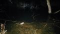
This is a lot of what I saw in the first section, but with more tufts of grass. This view is next to the path looking toward the hash.
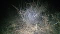
Hard to see in this picture, but to both sides I just saw a wall of this thick brush.
And where there were some small openings, it closed up pretty quickly.
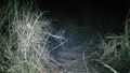
This was as close as I got on the path that I was on.
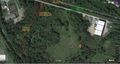
The diagram, with notes, of what went wrong.


Ribbons
The way the ribbon is worded, I think I can take the Blinded by Science ribbon. Also, I'm not sure about the Not Reached category. At the time, it was definitely Not Reached by Mother Nature because I wasn't able to get through. The Blinded by Science says it should be by Tech. Feel free to leave comments on the categories and laugh or commiserate at my ineptitude of this hash.
Pedalpusher earned the Blinded by Science Consolation Prize
|