2016-04-15 42 -79
| Fri 15 Apr 2016 in 42,-79: 42.2277317, -79.1728477 geohashing.info google osm bing/os kml crox |
Contents
[hide]Location
Harris Hill State Forest
Participants
- Pedalpusher
- Simon the dog
- Myka the dog
Plans
To extend my current consecutive streak, I'm going to drive to the Dunkirk Graticule, after work with the dogs, and try to get to the hash in the state forest. Unless it's in the middle of a swamp, it shouldn't be too bad since it's close to a dirt road that runs through this section. The rest of the weekend also looks great so I will try tomorrow and Sunday to keep this going. Links to the previous hash and tomorrow's hash.
Expedition
After work, we loaded into the car and pretty much just followed Rt 62 South almost all the way to the hash. About halfway down, we passed an accident that looked pretty bad. The driver missed the curve of the road and the deep ditch flipped the car onto the driver side. A large tree stopped whatever remaining forward momentum the vehicle had. The police were already on the scene when we passed by(the state trooper station was less than a mile down the road) and the Fire trucks/Ambulances were on their way. I couldn't find a news article on it, so hopefully the occupants were ok.
Getting to the state forest, I found a parking spot, by a hiking trail, a bit down the road from the forest road I wanted. With the dogs on leashes, we walked to the forest road and enjoyed an easy hike in. Getting to within about a tenth of a mile from the hash, we struck into the woods. This section of forest was very young with all the trees less than 5 or 6 inches in diameter.
Following the GPS, right next to the hash, was a very large dead tree that had broken off about 12 feet off the ground. It looked pretty rotted through but was still standing. Getting our pictures, we headed back to the road to see if we could find where it stopped. This didn't take long because about 100 yards/meters further, it just ended.
Remembering the trail we parked at, we hiked back to the car to extend our hike over there. It was a very nice but likely mostly unused trail. There was grass across most of it and it was a very different sensation than the hikes I'm used to. We were led across a stream and into a deforested area that they had recently logged. I found a note on a tree describing the history of the land. It was heavily farmed until the state acquired it when pines were planted to restore the soil. Now, the pines were reaching their end and were taken out and the land will now naturally reforest itself. The tree tops that were left will provide cover for Grouse and other small animals as well as provide protection for the new saplings as they grow from the white tail deer grazing.
Getting dark at this point, we made our way back to the car and headed for home.
Bonus note, this is my 64th successful expedition so I get to add the 2 to the 6th ribbon.
Photos
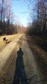
Walking on the road through the forest to the hash.
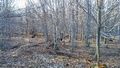
Leaving the road, this section of forest looks very young.
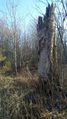
Doing the hash dance by this big dead tree.
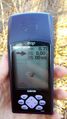
Just when I was about to give up, I got my favorite 0.00 reading.
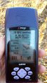
Accuracy.

Happy Consecutive hasher.
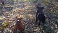
The dogs at the hash.


Ribbons
This user earned the Land geohash achievement
|
Pedalpusher earned the Consecutive geohash achievement
|
Pedalpusher earned the Two to the N achievement
|