2016-04-16 47 -122
| Sat 16 Apr 2016 in Seattle: 47.6422736, -122.3089662 geohashing.info google osm bing/os kml crox |
Location
On the Montlake playfield, just south of the 520 bridge.
Participants
Plans
This is a very easy hashpoint to arrive at, within a few blocks of the new Light Rail station in Seattle's University District. I plan to arrive at this very centrally located area at 4. Open to a stroll along the arboretum waterfront trail before or afterward.
- Nobody took me up on the offer, went to see Jungle Book instead - it was pretty good. Headed over there now. --Thomcat (talk) 01:33, 17 April 2016 (UTC)
Damn, didn't check the geohash. I literally could have walked to this one. Zebburkeconte (talk) 06:26, 18 April 2016 (UTC)
Expedition
As noted above, nobody showed up at 4pm for the official Saturday meetup. After the movie and a spot of dinner, I posted and headed to the spot. The park was quite nice (and dry - it can be muddy in spots) and the field was easily reached. There was a game of Jai Alai going on, two referees so it wasn't just a pickup or practice. Fortunately I showed up shortly before a break (halftime?) and also didn't have to wander very far onto the field to be "on the spot".
Easy geohash.
Tracklog
Photos
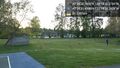
Hwy 520 @47.6421,-122.3092

Photo uploaded but wiki edit failed apparently
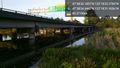
520 again @47.6430,-122.3089


