2016-04-18 52 0
| Mon 18 Apr 2016 in Cambridge, UK: 52.7606532, 0.5154285 geohashing.info google osm bing/os kml crox |
Location
A meadow divided into allotments near Pott Row, Norfolk, UK.
Participants
Plans
Two of three spanning midnight - 2016-04-18 52 1 - 2016-04-18 52 0 - 2016-04-19 52 0 - ETA 23:15.
Expedition
The expected meadow turned out to be allotments. These are small cultivated areas rented out to allotment holders who grow flowers, vegetables and fruit. Several of the zones had sheds for hens. This might be a very British tradition. I have not noticed this style of gardening on my travels abroad. Typically the allotment holders live in houses or flats with no garden.
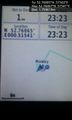
The hashpoint was easily reached. A gate blocked vehicles but there was pedestrian access round the side. The main access path led close. The final destination was over a rabbit fence, about ten paces into an allotment, between rows of seedlings. My GPSr time zone had corrected itself and I was running about 8 minutes late.
Photos
Arrival. @52.7607,.5154
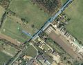
Google Earth Track


Achievements
Expeditions and Plans
| 2016-04-18 | ||
|---|---|---|
| Mannheim, Germany | Q-Owl | Between Gernsheim and Allmendfeld in the upper Rhine valley; located on a c... |
| Cambridge, United Kingdom | Sourcerer | A meadow divided into allotments near Pott Row, Norfolk, UK. |
| Norwich, United Kingdom | Sourcerer | A footpath point, south of Stalham, Norfolk, UK |
Sourcerer's Expedition Links
2016-04-18 52 1 - 2016-04-18 52 0 - 2016-04-19 52 0 - KML file download of Sourcerer's expeditions for use with Google Earth.