2016-06-15 52 1
| Wed 15 Jun 2016 in Norwich, UK: 52.8594641, 1.0435540 geohashing.info google osm bing/os kml crox |
Location
A field North East of Melton Constable, Norfolk, UK. There is a public footpath quite close.
Participants
Plans
One of two spanning midnight - 2016-06-15 52 1 - 2016-06-16 52 1 - ETA 22:55.
Expedition
My pigeon brain failed. This is the bit responsible for homing and navigation. Of course this was inherited from a common ancestor, probably marine and not in direct line from a pigeon. So a most inefficient route was followed, arriving 50 minutes later than planned. There was tall wet vegetation for most of the route. I could hardly have got wetter by wading a waist deep stream.
Approach one from the north was potentially successful but over 100 metres of crop trampling would have been needed. Abort!
Approach two through a recreation ground with children's swings, slides and soccer goal posts also led to the correct field. A bushwhack through head high nettles and brambles led into the field. A wet perimeter path led close to the hashpoint. There were multiple tractor tracks where crop sprayers had negotiated a path round what might have been a world-war-two bomb crater. The tracks led to the hashpoint. Several more craters can be seen in the Google Earth Image, below.
With 15 minutes to spare, before my GPSr turned back into a pumpkin, success!
Photos
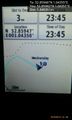
Arrived. @52.8594,1.0435
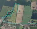
Google Earth Track


Achievements
Sourcerer earned the Last man standing achievement
|
Expeditions and Plans
| 2016-06-15 | ||
|---|---|---|
| Norwich, United Kingdom | Sourcerer | A field North East of Melton Constable, Norfolk, UK. There is a public foot... |
Sourcerer's Expedition Links
2016-06-14 52 1 - 2016-06-15 52 1 - 2016-06-16 52 1 - KML file download of Sourcerer's expeditions for use with Google Earth.