2016-07-20 52 1
| Wed 20 Jul 2016 in Norwich, UK: 52.8975584, 1.1136620 geohashing.info google osm bing/os kml crox |
Location
A field perimeter point between Holt and Hempstead, Norfolk, UK.
Participants
Plans
One of two spanning midnight - 2016-07-20 52 1 - 2016-07-21 52 1 - ETA 21:55.
Expedition
After a hot day with thunderstorms, it was shorts weather. The wet barley field soaked my feet and legs but the shorts remained dry. A public footpath ran parallel with the field and easily-followed tractor tracks led to the hashpoint. It was dusk. The rain had stopped. The moon had not yet risen above the low clouds on the horizon.
On my drive home I saw a "biblical" pillar of fire. Moonlight was shining on tall cumulonimbus clouds. The moon itself could not be seen and the clouds looked like flame, 20 000 feet high.
Photos
- Photo Gallery
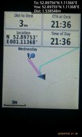
Arrived. @52.8975,1.1137
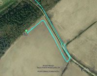
Google Earth Track


Achievements
Expeditions and Plans
| 2016-07-20 | ||
|---|---|---|
| Norwich, United Kingdom | Sourcerer | A field perimeter point between Holt and Hempstead, Norfolk, UK. |
Sourcerer's Expedition Links
2016-07-18 52 1 - 2016-07-20 52 1 - 2016-07-21 52 1 - KML file download of Sourcerer's expeditions for use with Google Earth.