2016-07-29 52 1
| Fri 29 Jul 2016 in Norwich, UK: 52.2610541, 1.3857076 geohashing.info google osm bing/os kml crox |
Location
Woodland close to a field perimeter, Badingham, Suffolk, UK.
Participants
Plans
Go at dusk.
Expedition
Grrrrrr! I should have ploughed through the middle of the crop following the path which should have been marked. To avoid crop damage, I followed tractor tracks but these led to a nettle filled ditch, blocking my escape route. Of course I crossed the ditch, paying a price. I have stung hands, knees and backside! Ouch!
The rest of the walk was much easier. The paths were clear and marked. Near the hashpoint I could follow tractor tracks through a ripe wheat crop. The hashpoint was 12 metres into the woodland. This required a squeeze through the perimeter growth. Under the trees it was quite clear.
There was light rain for most of the walk. In the image below, the green dashes mark the missing path. My route was widdershins (anti-clockwise). Wikipedia says its unlucky to go widdershins around sacred land. A rectory was at the centre of my route so perhaps that's why I now have a stung arse!
Yea! APBot seems to be working again.
Photos
- Photo Gallery
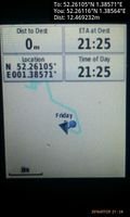
Arrived. @52.2612,1.3856
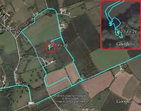
Google Earth Track


Achievements
Sourcerer earned the OpenStreetMap achievement
|
Expeditions and Plans
| 2016-07-29 | ||
|---|---|---|
| Rennes, France | JwB | A field near St Aubin du Cormier |
| Norwich, United Kingdom | Sourcerer | Woodland close to a field perimeter, Badingham, Suffolk, UK. |
| Kolding, Denmark | FelixTheCat | Hammelev, Denmark. |
Sourcerer's Expedition Links
2016-07-25 52 1 - 2016-07-29 52 1 - 2016-07-31 52 1 - KML file download of Sourcerer's expeditions for use with Google Earth.