2016-09-13 52 1
From Geohashing
| Tue 13 Sep 2016 in Norwich, UK: 52.1875814, 1.2198325 geohashing.info google osm bing/os kml crox |
Location
A field in central Suffolk south of Framsden, UK. It's close to a public footpath.
Participants
Plans
Go at dusk. Take advantage of the moonlight.
Expedition
There was a place to park at the village hall. A public footpath crossed a stream and headed uphill and south towards the hashpoint. A wide grassy field perimeter led to the point without trespassing into the cultivated area.
On the return walk I diverted past the church to gather potential mapping data for OpenStreetMap.
Photos
- Photo Gallery
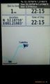
Arrived. @52.1876,1.2198
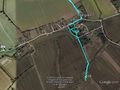
Google Earth Track


Achievements
Sourcerer earned the OpenStreetMap achievement
|
Expeditions and Plans
| 2016-09-13 | ||
|---|---|---|
| Atherton, Australia | Felix Dance | In the bush next to a dry creek, inside 'No Trespassing' pastoral land. |
| Köln, Germany | DODO | A field near Heckhuscheid (Eifel). |
| Cambridge, United Kingdom | Tongs/B | A field beside a railway line at the end of Highfield gate, Fulbourn, near ... |
| Norwich, United Kingdom | Sourcerer | A field in central Suffolk south of Framsden, UK. It's close to a public fo... |
Sourcerer's Expedition Links
2016-09-09 52 1 - 2016-09-13 52 1 - 2016-09-21 52 1 - KML file download of Sourcerer's expeditions for use with Google Earth.