2016-11-20 45 -122

| Sun 20 Nov 2016 in 45,-122: 45.5537771, -122.3583243 geohashing.info google osm bing/os kml crox |
Location
Just off a hiking trail in the north central area of the Sandy River Delta Park.
Participants
Plans
I get warnings in my email whenever there's a hash that's relatively nearby thanks to geohashingnotifications@gmail.com, and I was pretty curious about this one since it was in a park I've never been to. I ended up fairly close, at Luke's house, and when we ran out of things to do that day, I suggested this game and he was immediately interested.
Expedition
We drove over in my SMART car, and got a lot closer than the map would actually have you believe. We still had to hike in, which was a bit tougher than we expected because all the trails were boggy. There are a couple off-leash dog trails, which was really cool since various dogs would randomly run up to us and say hello as if they were just permanent residents of the area, and it was fairly difficult to tell which of the human hikers owned which dogs—they all just seemed to be independent of each other.
Navigating to the location was very easy thanks to the hiking trails being programmed into Google Maps' map view, in conjunction with being able to see the satellite imagery. At the very end, we had to turn off the "trail" in the map view, but there was an access road that was actually even easier to walk on because it wasn't as trampled; the plant life allowed us to stay above the boggy soil while still being flattened enough by the vehicles that must occasionally visit this place to provide good direction.
We finally reached a spot where we had to turn off the access road, and this ended up being a small farm-like location where saplings of a certain kind of tree (?) were being grown. We weren't able to identify the plant, but the farm set-up was fortunate, because we were able to figure out exactly where the hash was by following the rows of saplings. There were flags of various colors stuck into the earth at arbitrary locations here and there, and we were very surprised and delighted to discover that at the exact location where the hash seemed to be on the satellite view was a bright red flag right next to a cute young shoot sprouting new leaves waiting for us to discover it. It was the only red flag in the area!
We took a few photos, stood around and took off. Didn't leave any markings figuring that the flag was going to be good enough already! On the way back we had our only unfortunate run-in—a pair of small but vicious dogs ran at us with fierce anger in their eyes, and one of them actually ran up to me and bit me hard on the ankle. The owner was very apologetic, and explained that it was because of the very unique hat that I was wearing. I certainly understand that this hat is not something that you might consider preparing for, but in my defense, domestic canines should not ignore their master even when their basest urges well up inside them. I'll call that a draw.
The path back was easy and relaxing, and the weather (though constantly threatening with rainfall) never turned and we managed to get out of there quite dry, and only with the tiniest amount of mud on our shoes. I'm very glad to have gone!
Photos
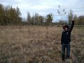
Success!
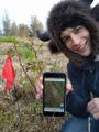
Stupid Grin, GPS, and Flag.
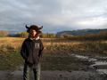
More Sandy River Delta Park scenery.


Achievements
zhukant earned the Land geohash achievement
|