2017-01-13 48 -3
| Fri 13 Jan 2017 in 48,-3: 48.5839445, -3.2563727 geohashing.info google osm bing/os kml crox |
Location
In a hedge in the small rural town of Pédernec, Brittany, France.
Participants
- Ourlig
- Gribouille the dog
Initial plans and preparation
Not planned much, really. It was the third day in a row that I checked if there was a hashpoint I could reach. I had chickened out the previous days. This time, I'm going !
Expedition
It was windy, chilly, with frequent showers and hail from time to time but I'm not going to wait for the perfect day, the perfect weather. So I grab my camera, a tripod, my phone, my GPS, the leash and off we go. Gribouille thinks we are going for a walk. She is about to be disappointed...
The first half hour is boring : I take the same road to go to work everyday. then it's the freeway for less than ten minutes, a small road and finally, a country lane. The GPS tells me I'm 20 meters from the hashpoint. I stop the car, wait for a shower to stop and I'm out. I first check with geohash droid to see if my gps is accurate. it seems to be. Two guys arrive on dirt bikes but they continue past me. They are not geohashers (which I must admit would have been VERY surprising !) I find a small piece of dead wood that i can carve onto and leave on the hashpoint. The result isn't very good but I hope I will have future opportunities to improve. I finally walk to reach the hashpoint. It's in the middle of an hedge. I put the mark I just did, take a couple of pictures (sorry proofs) and get back in the car. Gribouille doesn't understand what we are doing here so on my way back home, I stop nearby work to do a short walk with her.
To be true, the most existing thing today has been editing this wiki as it's a first time for me.
Photos
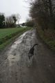
The last bit of "road" I took before leaving the car. Gribouille discovers a new spot.
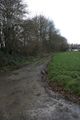
The hashpoint is somewhere in this hedge some 20 metters away. Let's go and find it !
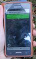
as the app suggests : Yay ! I'm there

That's a bad grin...
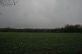
On the other side, a typical field with some wind turbine in the back.


