2017-01-23 52 1
From Geohashing
| Mon 23 Jan 2017 in Norwich, UK: 52.4163709, 1.5065222 geohashing.info google osm bing/os kml crox |
Location
A field between Ilketshall Saint Andrew and Beck's Green, Suffolk, UK.
Participants
Plans
One of two spanning midnight - 2017-01-23 52 1 - 2017-01-24 52 1 - ETA 23:05.
Expedition
The ground was frozen and there was freezing fog but the temperature was on the rise. It has been a dry winter so there was little ice on the roads. There was a good concrete area to park and tractor tracks led through a ploughed field to the hashpoint. I was early. I had allowed more time for the fog and ice.
Photos
- Photo Gallery
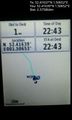
Arrived. @52.4164,1.5065
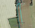
Google Earth Track


Achievements
Expeditions and Plans
| 2017-01-23 | ||
|---|---|---|
| Zürich, Switzerland | ThreeFx | Next to one of the main roads near Affoltern. |
| Mannheim, Germany | DODO | A field in the nature reserve "Backofen-Riedwiesen" between Brühl-Rohrhof ... |
| Norwich, United Kingdom | Sourcerer | A field between Ilketshall Saint Andrew and Beck's Green, Suffolk, UK. |
| Utrecht, Netherlands | JwB | Planted forest in Lelystad |
Sourcerer's Expedition Links
2017-01-06 52 1 - 2017-01-23 52 1 - 2017-01-24 52 1 - KML file download of Sourcerer's expeditions for use with Google Earth.