2017-02-12 52 1
From Geohashing
| Sun 12 Feb 2017 in Norwich, UK: 52.2595529, 1.3082986 geohashing.info google osm bing/os kml crox |
Location
A field between Tanningtom and Maypole Green, Suffolk, UK.
Participants
Plans
One of two spanning midnight 2017-02-12 52 1 - 2017-02-13 52 1 - ETA 23:05.
Expedition
The snow had melted leaving dry grass but wet muddy fields. At least there was little standing water in the fields. There was some welcome moonlight after days of cold dull overcast weather. The temperature had risen from zero to about 4C. Perhaps spring is on its way. Close to the field entrance, there was a concrete bay for farm vehicle loading. The grassy field perimeter led close. There was a 35 metre mud trek to the hashpoint.
Photos
- Gallery
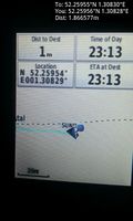
Arrived. @52.2596,1.3083
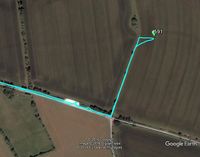
Google Earth Track


Achievements
Expeditions and Plans
| 2017-02-12 | ||
|---|---|---|
| Frederick, Maryland | Someone went | Comus, MD]... |
| Norwich, United Kingdom | Sourcerer | A field between Tanningtom and Maypole Green, Suffolk, UK. |
Sourcerer's Expedition Links
2017-02-11 52 1 - 2017-02-12 52 1 - 2017-02-13 52 1 - KML file download of Sourcerer's expeditions for use with Google Earth.