2017-03-11 42 -78
| Sat 11 Mar 2017 in 42,-78: 42.0352229, -78.6818387 geohashing.info google osm bing/os kml crox |
Contents
[hide]Location
In the woods of Allegany State Park by Limestone
Plans
Very similar to the 2016-03-25 expedition, I'm going to park in the same place but the hash is on the other side of the road. There are a few hills to navigate around getting to the hash, but it shouldn't be too bad. I'll be aiming for an Official Saturday Meetup, and it looks like it's going to be a bit over a mile as the crow flies. If I give myself about 45 minutes to walk, I should get pretty close to the 16:00 arrival time without having to rush.
Participants
- Pedalpusher
- Simon the dog
- Myka the dog
Expedition
Figuring out my timing, I knew I had to leave the house by 14:00 to hopefully arrive at the hash by the 16:00 meetup time. However, I was playing a little Kerbal Space Program beforehand. My space program is doing very well, but I've been having a terrible time building stable flight airplanes. My best plane is good on take-off but upon attempting to turn, likes to just do barrel rolls until it crashes. Playing around with the design, I somehow stopped the spin and created a fantastically stable craft! I was so excited to fly it around that I...kinda lost track of time a little. Right at 14:00, I managed to put the game down and get ready to go.
I wanted to get some pizza dough going so it would be ready when I got back and I was finally ready to leave around 14:30. The drive down wasn't too bad until we got close to Ellicottville where we hit some snow. It was pretty weird snow, as the road would be clear and no snow, then a minute later it would be really heavy snow. A little while longer, and it would be clear again. Pretty indicative of lake effect snow. I managed to find the road by the hash without difficulty, but getting to the park land, I saw a Road Closed sign and like my last expedition to Allegany, I knew I would be walking a bit further than I planned. There was an open area next to the road by the Road Closed sign and I was REALLY tempted to park there despite the No Parking - Plow Turnaround sign, I decided the better spot was on the side of the road on the opposite side.
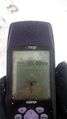
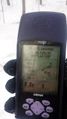
As we started to walk up the road, I heard a low rumbling and scraping sound, and would you believe the plow was clearing the road! I was really glad I parked safely and continued on. Looking at the GPS, I saw we were about 0.7 miles from the hash and closer than if we had parked at the pipeline as planned. With the woods along the road not posted, we cut in and headed directly to the hash. The first hill we hit was steep but not too bad and we cleared it with a little huffing and puffing, but no stopping. Cresting the hill, we had about 0.2 miles to go and it looked like it was near the top of the next hill to the right. Walking over and trying not to give up too much elevation, I found I could have dropped down because the hash was actually close to the bottom of the incline. Unfortunately, this side was steeper so after careful sliding down using trees around for balance, I did the GPS dance for a satisfactory reading. Looking at my phone, I realized with all the changes, we actually timed it perfectly and it was only a few minutes past the Official Meetup time!
Success had, we headed back and I aimed to walk toward the road at an angle(toward further up the road) to extend our hike a little on the way back. I'm glad I did because I came across some large granite rocks, smaller than, but similar to the Thunder Rocks at Allegany, just up the road. As we continued back to the road, it started snowing and ended up getting pretty heavy. I started to worry a little and wanted to confirm I was still going in the right direction. I pulled out the GPS to point us in the direction of the waypoint I set before leaving the road earlier, but as it was finding satellites, the batteries died in the cold. As I started to pull the spares out of my pocket, the road appeared out of the snow.
We had a careful drive home and hit a few more pockets of snow, but made it safely and I enjoyed delicious home-made beer and pizza for dinner.
Photos
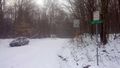
A good thing I parked across the road or I would have been in trouble.
Made it.
Accuracy.

Happy to make it...

...for a Frozen, Official Sat. Meetup too.
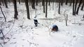
The dogs at the hash with their sticks.
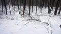
A view of the woods from the hash.
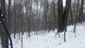
Starting to head back, a view of the hash to the right of the branch on the ground.
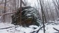
On the way back, some of the big rocks I found.
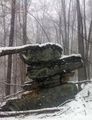
They were all together in a big group.
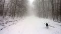
Getting back to the road, it was very snowy for a few minutes.


Ribbons
This user earned the Land geohash achievement
|
Pedalpusher earned the Frozen Geohash Achievement
|
Pedalpusher earned the xkcd Nullaturion achievement
|