2017-03-15 52 1
From Geohashing
| Wed 15 Mar 2017 in Norwich, UK: 52.3915635, 1.3954586 geohashing.info google osm bing/os kml crox |
Location
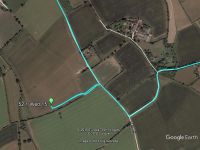
A field between St. Margaret and St. James, South Elmham, Suffolk, UK.
Participants
Plans
One of two spanning midnight - 2017-03-15 52 1 - 2017-03-16 52 1 - ETA 23:10.
Expedition
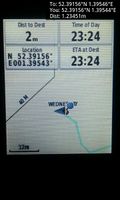
There was roadside parking and a public footpath. The hashpoint was about 20 metres off the path in a rape-seed field. There was a propane explosive bird scare machine lurking about 15 metres from the hashpoint. There was a dull red glow from the LED power indicator. At night the gun-shot sounds stop.
Photos
- Gallery
Arrived. @52.3916,1.3954
Achievements
Expeditions and Plans
| 2017-03-15 | ||
|---|---|---|
| Victoria, British Columbia | Wijnland | In front of Esquimalt Harbour, between Fishgard lighthouse and Brothers Isl... |
| Mannheim, Germany | DODO | In a nurserynext to Schifferstadt |
| Kassel, Germany | GeorgDerReisende | The hash lay in the forest south of Calden. |
| Norwich, United Kingdom | Sourcerer | A field between St. Margaret and St. James, South Elmham, Suffolk, UK. |
| Utrecht, Netherlands | JwB | A field near Almere, almost no deviation from my commute needed. |
Sourcerer's Expedition Links
2017-03-07 52 1 - 2017-03-15 52 1 - 2017-03-16 52 1 - KML file download of Sourcerer's expeditions for use with Google Earth.

