2017-06-22 67 27
| Thu 22 Jun 2017 in 67,27: 67.5072053, 27.7352907 geohashing.info google osm bing/os kml crox |
Location
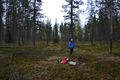
Savukoski, Pyörreseljänmännikkö, between Värriö and Tanhua. The point lies in a pine forest.
Participants
- Pastori
- The Wife
Expedition

Since Pastori and Wife were spending the longest day of the year in the northern hemisphere north of the Arctic Circle, Pastori suggested that they make their day a little longer and go for a romantic nightly outing to the nearest hashpoint. The aim was to be at the point at midnight.
The distance to the point was a little over 100 km so they set out in plenty of time, at around 10 pm. Slowly they traveled on the same route as the previous day for about half the way towards the north-east. There was plenty of the Savukoski municipality to go around for both points, even though today's was another unconquered graticule, Pyhäjärvi. The area is rugged and the roads are few and far apart and Pastori was already daydreaming about a helicopter. But for now Pastori's little vehicle takes them where they need to go. They traveled nicely through the drizzling rain and made it to the point about 15 min before midnight.
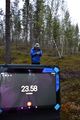
During preparation the accuracy of the point fluctuated between 4 and 12 meters. But once they had laid out their picnic and drank their hot chocolate it was finally midnight and they accuracy was 5.729 m, excellent achievement. The atmosphere was nice and they were feeling joyful despite the modest picnic, the temperature of +4 degrees Celsius and the drizzling rain. This was certainly an experience and a new graticule in the bright summer night. These pictures have indeed been taken in the middle of the night under heavy clouds. In Lapland there is as much (or as little) light in the night as in the day, so they missed the actual midnight sun this time around, it being covered in clouds. But the trip was excellent fun so Pastori and Wife are definitely living according to their geohashing philosophy.
Statistics: all in all 4 hours, in the car 224.4 km, average usage of gasoline 4.6 l/100km, average speed 65 km/h, on foot 444 m, temperature +4 degrees Celsius, altitude from sea level 259 m, 3 reindeer, 8 hares, 1 cat.


Photos
Get set...
…ready...

GPS proof.

Start.


Achievements
Pastori earned the Midnight Geohash achievement
|
Pastori earned the Land geohash achievement
|
Pastori earned the Graticule Unlocked Achievement
|
Pastori and The Wife earned the Picnic achievement
|
Pastori achieved level 4 of the Minesweeper Geohash achievement
|