2017-07-16 42 -78
| Sun 16 Jul 2017 in 42,-78: 42.8192469, -78.8218976 geohashing.info google osm bing/os kml crox |
Contents
[hide]Location
Veteran's Park in Lackawana, in the middle of the playing field
Participants
Expedition
The original plan when I first saw the coordinates on Friday was to ride my bike over in the morning, however, I remembered I had plans and so was thinking I needed to drive. Being in the outfield of a baseball diamond and being summer, I fully expected the field to be used all day(being a weekend). Which was why I was thinking I needed to get there early before practice/games started. I also considered taking the chance and going in the evening, but I'm glad I didn't as I would have run out of time.
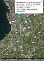
After breakfast, I drove to the hash straight North on Rt 62(I have to do some calculations for a Juggernaut) and getting to the field, I hopped out happy to see the parking lot empty. I had my GPS in the car but I didn't enter the coords before I left the house. Being lazy, I got out my phone and used the HashDroid app. Walking into the field, my phone was having some trouble, but I continued walking toward where I thought the hash was. As I got close and needed to fine-tune my position, my phone still had my location bouncing all around the park. 500 feet away, 620 feet away, going from the corner by the street to the opposite corner by the other side of the park. Not once did I see my location enter the field with the hash. Rather than walk back to the car for the real GPS, I ended up just using the map(satellite view) and with landmarks, approximating the position for what I think falls within the rules of a No Batteries Geohash.
Being as successful as primitive methods allow, I took my pictures and headed back to the car and continued to the Cadillac dealer for the car show. Every year, they hold a car show and have a cookout, but to sell food, it's a headache for the dealership. So they wanted to call in a non-profit to do the cooking and selling and with a Camp Weona Board member working there, we were selected to run the cookout. We raised around $600 to help send kids to camp! While I was there, my mom called asking if I wanted to stop by their house for dinner that evening. Agreeing to that, I would likely not have had a chance to get to the hash on the way home. Parks generally 'close' at dusk around here.
For the Juggernaut calculations: Geohashing.info has the hash 7.01 miles from my house in Hamburg. Google Map directions has the distance at 7.3 miles. I don't have the exact mileage in the car as I didn't think about this until well after I got there...but...
These numbers give me a deviation of 0.29 miles and a ratio of 0.29/7.1 = 0.041 --> about 1:24 < 1:20 = Successful Juggernaut!
It was a beautiful day for a bike ride too so my only regret is having to drive, but at least it was on the way to my events.
Photos
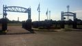
The entrance to the field was next to a Fire Station.
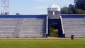
Out in the middle of the field, I lined up with the Grandstand 'Tunnel'.
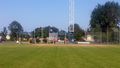
And to square off, the entrance gate on the right, not quite to the First/Second baseline.

Satellite view used to find landmarks for hash position.
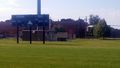
A view from the hash, looking at the scoreboard.

Glad to make it despite the Tech troubles.
For the Juggernaut, the distance from Home to Hash.
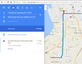
And the travel distance to the hash(probably slightly longer than the actual distance traveled to err on the side of caution for the calculation.


Ribbons
This user earned the Land geohash achievement
|
Pedalpusher earned the Juggernaut achievement
|
Pedalpusher earned the No Batteries Geohash Achievement
|