2017-07-31 52 1
| Mon 31 Jul 2017 in Norwich, UK: 52.4046955, 1.2500251 geohashing.info google osm bing/os kml crox |
Location
A public footpath half way down a field perimeter at South Green, Norfolk, UK.
Participants
Plans
Go after lunch.
Expedition
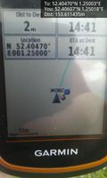
This was easy enough at 15 km from home. With mild 23C temperatures and periods of sunshine, the excursion was pleasant. The hashpoint was 140 metres from the roadside parking along a public footpath. It was unclear which side of the drainage ditch to walk but it didn't matter. The hashpoint was in the narrow ditch and by leaning, it could be reached from either side.
My phone battery died just after taking the evidence photo but before the upload to the wiki. That was a pity because the adjacent fields were full of cultivated roses of every colour. Too bad there'll be no photo.
Photos
- Gallery
Arrived.
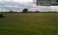
Lonesome tree near the hashpoint.
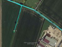
Google Earth Track.


Achievements
Expeditions and Plans
| 2017-07-31 | ||
|---|---|---|
| Genève, Switzerland | Crox, by proxy | Prangins, Switzerland, near the former HBG transmission site |
| Cambridge, United Kingdom | PaintedJaguar | On a public footpath just off Dunstan Street in Ely, and just over 350m fro... |
| Norwich, United Kingdom | Sourcerer | A public footpath half way down a field perimeter at South Green, Norfolk, ... |
| Utrecht, Netherlands | JwB | Parking lot in an industrial area in Almere |
Sourcerer's Expedition Links
2017-07-20 52 1 - 2017-07-31 52 1 - 2017-09-03 52 1 - KML file download of Sourcerer's expeditions for use with Google Earth.