2017-09-08 50 11
| Fri 8 Sep 2017 in 50,11: 50.8687581, 11.5911877 geohashing.info google osm bing/os kml crox |
Location
Maua
Participants
Expedition
Today's geohash was designed to adjust the average of hash-point likability back to a normal level again, after the last expedition has been some kind of lets call it disaster.
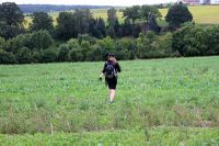
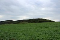
We met after work in front of Jujas office and rode relaxed in south direction. No hill, no thunderstorm, no blistering heat. After half an hour we arrived at the target area. To get at least a minimum of hash-point feeling we added a detour of 100 meters by choosing the wrong path first, then climbed up the highest mountain of the tour, fabulous 9 or 10 meters. To make it perfect, the field we had to cross was totally un-muddy. No need to say that there was no farmer around, guarding his field with a pitchfork.
After taking the usual photos we went back home, choosing a different way to make the tour a perfect round trip.
Photos
|


