2017-10-09 47 -122
| Mon 9 Oct 2017 in Seattle: 47.6773043, -122.2508183 geohashing.info google osm bing/os kml crox |
Location
A copse of trees in Magnuson Park, near the boat ramp
Participants
- Thomcat and dragalong daughter
Plans
Stop by after work.
Expedition
Traffic slowed my post-work commute, so I ended up picking up my daughter at school first. Then we went on an adventure!
The road to the boat ramp is actually a one-way road away from the boat ramp, which I didn't figure out until it was too late. In busy summer time this would have been a problem, but today I just went the wrong way and parked.
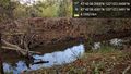
Glancing west and reading the gauge, I figured that the hashpoint would be on the other side of a stream. We headed down to where the path crossed said stream and then back towards the point. I spotted a pond and was a bit concerned the hashpoint would be in the water - but then realized I was turned around.
We proceeded to the approximate location and entered the site of former brambles - these had all been cut down less than a foot from the ground. Reaching this stream would have been nearly impossible before that. Unfortunately, I found that my first estimate was wrong, and the hashpoint was actually on the same side of the stream as the car!
Back tracking and recrossing, we proceeded to the hashpoint, which was on an elbow bend in the stream. A tree grew on the spot, and we reached it and snapped pictures. I did not bring my chalk to mark the trunk this time.
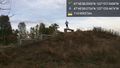
Returning to the car, we started out and then stopped at a sculpture/staircase somewhat near the point. This being a photo op, we climbed and snapped. Each of the "benches" had two repaired holes on the top - perhaps a rail was here? I believe it to be towards the bottom of column S and T on this map of the former Sand Point Naval Air Station.
This is my third geohashing visit to this area; 2014-02-03_47_-122 was fairly close by.
Photos
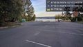
lake wa @47.6771,-122.2508
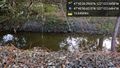
Stream @47.6774,-122.2507

Self @47.6774,-122.2507
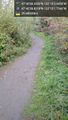
Path @47.6775,-122.2505
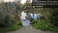
Pond @47.6775,-122.2501
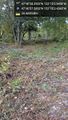
Trees @47.6771,-122.2507

Hashers @47.6773,-122.2508
Others side @47.6773,-122.2508
Intrepid! @47.6772,-122.2523


