2017-11-04 42 -78
| Sat 4 Nov 2017 in 42,-78: 42.0168508, -78.8054588 geohashing.info google osm bing/os kml crox |
Contents
[hide]Location
Allegany State Park, in the woods close to the Bear Caves Trail
Participants
- Pedalpusher
- Simon the dog
- Myka the dog
Expedition
I went to a Board 'retreat' in the morning, but it was at the Corporate office so not much of an actual Retreat, but we covered a lot and had a good meeting. We got out a little early so I rushed home and got the dogs in the car and we were on our way to Allegany a bit after 14:00. It would be close, but I should be almost on-time for an Official Saturday Meetup.
My initial plan was to park at the old Tornado site, walk up that trail and continue into the woods to find the hash. But after looking at the terrain map on Google, I realized I would have to walk over the mountain to get there this way. So I thought I would be better off parking at the closest Cabin trail instead. Arriving on the Quaker side of the park, I found the Creekside Trail and pulled in with a worried look.
With all the rain we've had over the past week, the creek, not a small one to begin with, was quite deep and flowing fast. Driving down and back not seeing any way to cross from the car, I parked and we walked through again so we could better see the creek. Alas, there was absolutely no where to cross without going calf deep in most places. Thinking I'd now have to go to my original plan, we walked back to the car and started driving, but shortly after that cabin trail ended, the creek crossed the main road and we had free access to the woods on the correct side. Finding a shower/restroom building, I pulled in and parked. It was a bit steeper here, but better than swimming.
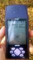
Starting up the hill, we worked our way back and up toward the hash. Halfway there, we crossed what appeared to be a trail and looking down it...oh, hey, there's a trail-marker. D'oh! I could have parked at the Bear Caves trailhead and had an easier walk up. Oh, well, we were almost there anyway. Getting close to the hash, I must not have had a great GPS signal because it was a long dance to get within a reasonable distance to the hash. With the short detour, I was slightly late for the Official Saturday meetup. However, being the only active hasher in the area, I'll still count it, being just 20 minutes late.
Getting my pictures, we headed back to the trail and with about an hour and a half before the sun set, we hiked North and away from the Bear Caves. On the way to the trail, I noticed two ticks on my pants. Grrrrrrrr! I found a rock and tried to crush them against it, but they both escaped. I periodically checked myself and the dogs and found a few on them too each time. I discovered I could actually crush the ticks between my thumb-nails in kind of a steam-roller fashion producing a small pop so I knew I killed it. By the end of the trail, I had killed at least a dozen and another check at the car found a few more...blood-sucking bastards!
A last check at home found two more on Simon, and on my way upstairs to a shower before bed, I scratched my neck and pulled another one off me. Gross!!! A thorough check of my body didn't find any more but I don't think we'll be hiking in that area of Allegany any more. I think I was successful at getting them all as a final check the next day did not find any more on the dogs or myself.
Photos
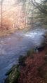
It was 'My Kingdom for a Boat' at this point.
Made it.
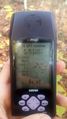
Accuracy.
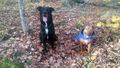
The dogs sitting (sort of) patiently at the hash.
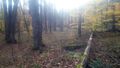
A view of the woods by the hash.

Standard Stupid Grin.
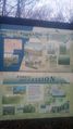
We stopped at the Tornado Site on the way out but the creek there was also too deep to cross. This is the sign with lots of information on what happened.


Ribbons
This user earned the Land geohash achievement
|
Pedalpusher earned the xkcd Decurion achievement
|