2018-05-08 49 8
| Tue 8 May 2018 in 49,8: 49.7543410, 8.7789276 geohashing.info google osm bing/os kml crox |
Location
In a forest in the Odenwald near Modautal.
Participants
Plans
- Timm: I'll take my bike and will probably arrive around 15:30.
- I won't be on time at all. I vastly underestimated the steepness and the lack of paved bike paths -- Timm (talk) @49.8148,8.7133 15:47, 8 May 2018 (GMT+02:00)
Expedition
I came home from uni around noon and was in the mood for cycling. The hashpoint was 20km away, so I got on my new old bike and took off for my first big tour through the Odenwald.
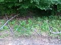
The trip turned out to be way more challenging than I expected; the bike only had 6 gears and I wasn't very used to cycling uphill, but the biggest problems were the unpaved mountain bike trails that OsmAnd chose for my route that I didn't check before leaving. However, I made it on top of the last hill in one piece and it was still light, so I was happy. The hash was in a thicket of undergrowth near the hilltop through which I had to climb to get within precision range. After taking a few pictures and spelling "XKCD" on the ground with a couple of branches (which will probably puzzle a forester), I left for home. The trip back was a little easier, maybe because my dying phone battery made me forgo OsmAnd's guidance.
Photos
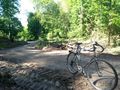
My bike
On top of the first hill
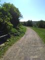
One of the more comfortable bike paths
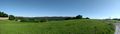
Panorama
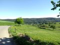
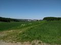
The hash is on top of the hill across this valley
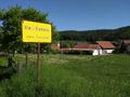
A village in the valley
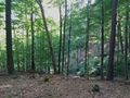
The forest near the hash
Proof
The internet was here

Grin


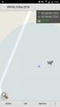
Tracklog
Alltrails - Only contains one way because my battery died.
Achievements
Timm earned the Two to the N achievement
|
Timm earned the Bicycle geohash achievement
|
Timm earned the Land geohash achievement
|