2018-05-16 52 1
From Geohashing
| Wed 16 May 2018 in Norwich, UK: 52.3149168, 1.4226435 geohashing.info google osm bing/os kml crox |
Location
A road hashpoint, south of Huntingfield, Suffolk, UK.
Participants
Plans
This easy road hashpoint lay half way between two places I had to go today. No brainer. Visit it!
Expedition
After walking with Waveney Ramblers, I had to visit the White Horse at Sibton to book us in on June 6th. The hashpoint was on the route. Zero miles. Almost zero effort.
Photos
- Gallery
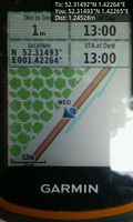
Arrived. @52.3149,1.4227
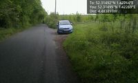
Hashpoint. @52.3149,1.4227


Achievements
Expeditions and Plans
| 2018-05-16 | ||
|---|---|---|
| Mannheim, Germany | DODO | A private house in Speyer. Just 460m from DODOs home, but probably unreacha... |
| Kassel, Germany | GeorgDerReisende | The hash lay 40 meters north of the Königschaussee in the Bergpark Wilhelms... |
| Norwich, United Kingdom | Sourcerer | A road hashpoint, south of Huntingfield, Suffolk, UK. |
Sourcerer's Expedition Links
2018-02-05 52 1 - 2018-05-16_52_1 - 2018-05-21_52_-0 - KML file download of Sourcerer's expeditions for use with Google Earth.