2018-06-26 48 11
From Geohashing
| Tue 26 Jun 2018 in 48,11: 48.0655139, 11.7164614 geohashing.info google osm bing/os kml crox |
Location
On a field next to the highway A99 near Putzbrunn
Participants
Plans
From the satellite image the hashpoint appeared to be on a field. Since I was nearby anyway I thought I'd give it a try.
Expedition
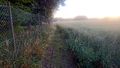
I used the small path nearby to get to the right side of the highway. The last few metres to the field were not easy since bushes and nettles were blocking the way. As I reached the field I realized that it wasn't possible to reach the point without damage to the rapeseed that was growing there. I took some photos and went back.
Photos
Proof of failure
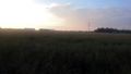
The hashfield I
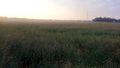
The hashfield II
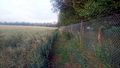
To the right
To the left

Stupid Grin (TM)


