2018-08-11 66 25
From Geohashing

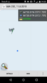
| Sat 11 Aug 2018 in 66,25: 66.3385797, 25.3616675 geohashing.info google osm bing/os kml crox |
Contents
Location
In Muurola.
Participants
Expedition
- Driving total 60 km
- Walking total 0.5 km
- Expedition took 2.0 h
- Physical effort (1-5): 2
This Hashpoint was quite near a small forest road. I had to walk 250 m to the Hashpoint through the forest. I was at the hashpoint 2.00 p.m. Expedition started about at 1.00 p.m. This point situated about 25 km from my home. This day was my 8th Hashiversary day!
Photos
The Proof
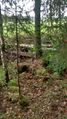
The Hash.

Me celebrating the 8th Hashiversary!.
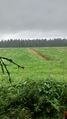
Nice view from the hashpoint.
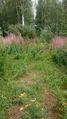
On the way back to the car.


Achievements
isopekka earned the Land geohash achievement
|
Isopekka earned the 8th Hashiversary achievement
|
Geohashing Expeditions and Plans on This Day
Expeditions and Plans
| 2018-08-11 | ||
|---|---|---|
| London West, United Kingdom | Saxbophone, TheOtterslider | Oxshott Heath, Surrey, England, UK. This location is Common Land —this mea... |
| Leipzig, Germany | Fluxkompensator | Leipzig city center. On Käthe-Kollwitz-Straße next to junction with Gustav-... |
| Kassel, Germany | GeorgDerReisende | The hash lay on a harvested field near Dörnberg. |
| Rovaniemi, Finland | isopekka | In Muurola. |