2018-08-17 51 9
| Fri 17 Aug 2018 in 51,9: 51.1612158, 9.5950060 geohashing.info google osm bing/os kml crox |
Location
In a forest near to the village Kehrenbach.
Participants
Plans
As I am writing this, it's short after midnight... I have to be at work tomorrow around 12:15 pm, so I will drive to Kehrenbach at about 9:30 am, arrive there one hour later and do a small hike of 30 minutes to reach the geohash, make some pictures and return to my car and then drive to work. I'm really looking forward to this 'expedition', since it will be my first (I only found out about geohashing last weekend!) but surely not my last...
Expedition
Before I get to the expedition itself, let me tell you that I first found out about geohashing only last weekend. And somehow I really got attracted to this idea of random coords being available only 24 hours and after reading some expedition reports, possible achievements and other silly things, I decided to join in on the 'game'! So, last monday I had a look at the coords, which were impossible to reach, and the same thing happened the days after. But then, yesterday night I saw the coords for today and I got quite excited, hehe. The location was more or less on my way to work and the hash seemed to be almost directly on a path through the woods...
So, I prepared everything, packed all the equipment I would need and took some hours of sleep. Got out of the bed 8:00 am, drank some coffee and drove to Kehrenbach, where I arrived at about 10:00 am... I parked my car at the grill hut and went for a hike to the hash. The weather was excellent - a lot of sun, nice temperature - and the first few hundred meters were quite steep so I even started to sweat a little. Since I have done a lot of geocaching the last four years, I couldn't resist to also visit three geocaches on my way to the geohash.
After 2,5 km I reached the geohash - I only had to leave the path and go into the forest for 30 meters or so, and even if the coords were jumping around quite heavily, I soon managed to take a picture to proof my visit. Nothing really spectacular, just some trees, but hey, I love getting around in the woods, so this one was quite fine with me!
Since I didn't want to turn around and go back the same way, I decided to walk on and choose another path back to my car. All in all, it was a very relaxing trip through a nice forest, and I felt somewhat excited about my first succesful expidition. I hope, many more may follow - let's wait and see what the DJI has in store for me hehe...
PS: This wiki-thing is also pretty new to me. Should I have made any errors or forgotten about something special, please give me some feedback or help - thanks in advance! I tried to do my best though ;-)
Tracklog
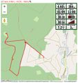
Todays track

Photos
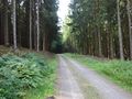
The way to the hash
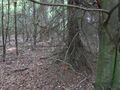
The geohash
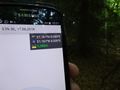
Proof
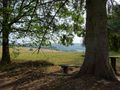
Nice view on my way back


Achievements
Digiphono earned the Land geohash achievement
|
Digiphono earned the Two to the N achievement
|