2018-08-23 50 -1
|
Dan Q also wrote about this expedition on his blog. For more details and higher-resolution pictures, see this expedition's log at https://danq.me/2018/08/23/geohashing-expedition-2018-08-23-50-1/ |
| Thu 23 Aug 2018 in 50,-1: 50.9582412, -1.0376621 geohashing.info google osm bing/os kml crox |
Location
Hyden Wood, near Chidden. The woods look to be criss-crossed with footpaths, so this might be pretty achievable.
Participants
Plans
I'd originally planned on heading to 2018-08-23 51 -1 because I anticipated that it'd be on or near my route travelling South along almost the entire length of the 51 -1 graticule, but I didn't bargain on such a Northerly hashpoint so I've changed plans and am now aiming to get to this one some time in the morning (I'm hoping to be in Winchester by lunch).
Expedition
The full story's in vlog format:
Here's the summary:
- Wasn't originally planning to come to this graticule but instead was going to go to the 51 -1 graticule where I live (see here): I was going to be driving almost the entire length of 51 -1 on a journey from Oxford to Winchester anyway, so I figured it'd be easy to divert to any hashpoint. But when the Dow numbers came out, it turned out that the hashpoints in this quadrant of the Earth are all in the North-East corner, and so my journey would be in the opposite direction. Oh no! So instead I decided to "overshoot" and go for this graticule instead, and thus (if successful) expand my Minesweeper Achievement level.
- Hashpoint deep in woodland in the beautiful South Downs National Park. Parked at The Sustainability Centre (and later made a donation via their website in thanks for the use of their car park despite not using their other facilities) and walked initially through woodland they manage and use for natural burials: this was really cool - I've always been a fan of body disposal in a low-environmental-impact, no-permanent-markers kind-of way, so I'm going to look more into what they offer. I was really interested to see that many families had left "named" bird nesting boxes in memory of their loved ones, which is awesome too.
- Found geocache GC2X5BJ just outside the burial area and close to a point that gave me a great view across a valley towards the woods in which I believed I'd find the hashpoint.
- Had to go some way off track to get to the hashpoint, but discovered a network of old, overgrown, long-abandoned (and not on any map I can find) trails in-between the thicket. In fact, the hashpoint eventually turned out to be on the edge of such a track, which I was able to follow to help me find my way back to a road.
- Found a sign pointing to "Droxford". Oxford is so-named because its location coincides with the most-downstream point on the Thames at which it's possible to ford the river while driving cattle (i.e. "ox ford") - incidentally, I'm told, the ford was at the point that Folly Bridge now stands. But what's the etymology of Droxford, I wonder. What the hell is a drox???
- On the way back, diverted by geocache GC5P5KN and found it: this was a great cache with the best-made variant of the particular kind of container it used that I've ever seen.
Update: A little research later, it seems that the "ox" in each of Oxford and Droxford have completely different etymological roots! Droxford is derived from an ancient name for the area from some time prior to the Middle Ages: Drocenesforda. "Drocen" means "dry": the name means "dry ford". The River Meon, which flows through the area, flows shallow over a chalky bed and is easily forded in many places, as these motorcyclists show. The things you learn!
Tracklog
- Download full tracklog (includes boring bit where I drive down the A34, too...)
Video
- My vlog of the expedition, for if you like to watch a sweaty man complain about there being too many trees in the woods
Photos

Edge of the woods

Panorama of the Natural Burial Site that I passed through
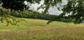
Looking across the valley, I can see the woods on the other side that I believe to contain the hashpoint

This path looks like the best route towards it
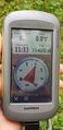
Success! You can't get closer than this!

Panorama of the hashpoint, which surprisingly fell on a disused and unmarked trail

Silly (and damp) grin

A clever geocache container is in this photo...
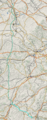
Full tracklog map, including my drive all the way down from Oxford
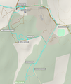
Annotated map showing the walking part of the expedition


_grin.jpg)


Achievements
DanQ earned the Consecutive geohash achievement
|
DanQ achieved level 3 of the Minesweeper Geohash achievement
|