2018-09-29 42 -79
| Sat 29 Sep 2018 in 42,-79: 42.3480923, -79.1368485 geohashing.info google osm bing/os kml crox |
Contents
[hide]Location
On the edge of a field on Dybkas Rd
Participants
Expedition
With not much planned for this weekend, I saw this was a sure shot that wasn't too far away, but I didn't want to drive an hour just to stop on the side of a road for 2 minutes. Checking out google maps, I saw there was a State Forest that was about 10 minutes from the hash and thought that would be a good new place to explore and hike around with the dogs.
On Friday, my sister called asking if I wanted to join her for dinner with my grandmother on Saturday and I figured I could still make this an Official Saturday Meetup. I would just have to be careful of the time. My plan was to leave around 13:00 and hike for 2 hours and have enough time to get to the hash around 16:00.
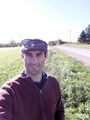
As always, I was running a bit late and ended up leaving at 13:25 getting there a bit after 14:00. This gave me about 40 minutes to hike out so I could get back to the car by 15:50. It was a pleasant but cool hike but the terrain was mostly flat. Apparently, I like a bit of steepness to my hikes because I was kind of 'Meh' about it afterwords. Anyway, with the dogs a bit tired, we drove off for the hash and I found the hash-road without any difficulty. We turned around and parked by the hash and while I didn't have a great reading in the car, we definitely passed within the Circle-of-Uncertainty. Because the Hash was on the side of the road and the field next to it was posted, I left the dogs in the car while I did the GPS dance to get a zeroed in reading.
With another Official Saturday Meetup in the books, we headed home to meet up for dinner by my house in Hamburg.
Photos
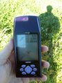
Made it.
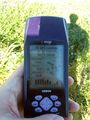
Accuracy.
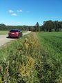
View of the Hash-mobile, looking East.
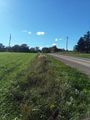
A view from the hash looking West, up the road
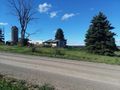
Across the road appeared to be an abandoned house.
Another successful adventure.

Official Saturday Meetup.


Ribbons
This user earned the Land geohash achievement
|
Pedalpusher earned the xkcd Decurion achievement
|