2019-03-22 45 4
| Fri 22 Mar 2019 in 45,4: 45.8203586, 4.8023541 geohashing.info google osm bing/os kml crox |
Location
Participants
Plans
When at work, I noticed the daily coordinates were only about 11 km from my location. I decided I would bike there on my way back home.
Expedition
I left work at 19:40, followed the Rhone river northwards, took the Tunnel de la Croix-Rousse, followed the Saône river until Saint-Rambert, where I noticed the path I wanted to take was closed to bicycles. I headed back, climbed a steep street named rue Louis Bouquet, continued through Saint-Cyr-au-Mont-d'Or and Saint-Didier-au-Mont-d'Or and reached the coordinates at Les Gorges bus stop at 20:35 having climbed about 200 m.
It was easier and faster on the way down.
Then I forgot to document the expedition for almost a year and a half.
Photos
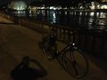
The Saône, my bicycle and me (shadow)
Self congratulation after a hard climb
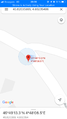
Coordinates reached
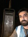
Stupid grin
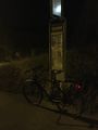
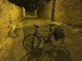
My bike at the coordinates
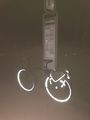
Shiny and chrome


Achievements
Baarde earned the Land geohash achievement
|
Baarde earned the Bicycle geohash achievement
|
Baarde earned the Two to the N achievement
|
Baarde earned the Graticule Unlocked Achievement
|