2019-05-11 43 1

| Sat 11 May 2019 in 43,1: 43.6945594, 1.6311787 geohashing.info google osm bing/os kml crox |
Location
In the commune of Montpitol, in the Haute-Garonne department, located on a strip of grassland between two crop fields, not far from the roadside.
Participants
Plans
Since it's not too far from Toulouse, the plan was to get there on bike, completing Tron achievement and Bicycle geohash achievement in one go.
Expedition
The bicycle lane is mostly continuous up to L'Union, but starting from Saint-Jean it's a lot less well developed. The wind was capricious on this day and changed directions all the time, plus up till Castelmaurou the ride was uphill, which is not what I've been accustomed to do anymore since quite a while. Still, after Castelmaurou I entered the true countryside with considerably less cars and a downhill section which helped a lot.
When I got to the field, I didn't want to leave my bike at the roadside so that I'd have to go back to the same spot to retrieve the bike, so I took my bike into the strip of grass land beside the field - not a very wise move. Trekking through the high grass while dragging a bicycle was really trying, and at one moment I almost lost my phone in the grass, which was followed by a brief moment of lost signal... In the end I turned around in circles for a bit to find the right spot, more or less invalidating the Tron achievement claim, but at least ultimately I found the hashpoint. I made a quick photo, crossed the small but deep stream that separated the two fields without getting myself or my bike wet, and exited the field through another strip of grassland without attracting attention or damaging the crop (if I lay low in the high grass, literally no one could see me from the roadside anyway: a car approached when I was out of the field, but luckily it didn't stop to raise any questions.)
The way back was more strenuous because now both the hilly terrain and the wind worked against my favor, especially before reaching Beaupuy: as its name suggests ("beau" beautiful + "puy" mountain), the village is located on top of a hill. I managed to get home, amidst stressful traffic from Montrabé to Balma, with only a minor cramp once I already arrived in Toulouse.
Tracklog
[GPX file] [Strava activity log]
Photos
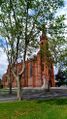
Church of Saint-Jean

Kind of flustered at the hashpoint
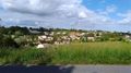
A group of houses in a village near Verfeil
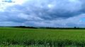
Grass field on the roadside of Beaupuy


Achievements
Epingchris earned the Bicycle geohash achievement
|
In retrospect, I could have taken a camera for photo evidence, and left the telephone on the bike by the roadside to make sure the really has no overlapping on the GPS tracklog. Still, I feel like the messy part around the hashpoint *kind of* is acceptable, so I'd like to half-claim the Tron achievement for now unless there is serious opposition. I'm definitely looking for chances to do a more clean-cut, legitimate Tron achievement though, at which point I'll gladly remove the Tron achievement for this geohashing. Actually, never mind: upon relooking my GPS tracklog, I realized (remembered) that I did go into a dead-end street and backed out once on the way back, so it definitely does not count as a Tron achievement. Well, better luck (at being more careful) next time!