2019-07-09 54 13
| Tue 9 Jul 2019 in Greifswald, Germany: 54.1319354, 13.3853162 geohashing.info google osm bing/os kml crox |
Location
In a field north of Neuenkirchen, MV, Germany.
Participants
Plans
Since today's hash fell relatively near, I plan to go there in the morning by bike and hopefully be able to be back in about 2 hours or so. Today is not weekend, so it can't take too much ;)
According to OSM there should be a path along a canal in the edge of the field, but knowing these fields and how they change year after year, I am not so sure there will be such path. Satellite imagery suggests that the tractor tracks pass over the hash, so there is my hope. Let's see what I will find.
Expedition
I grabbed Winterbuche at about.. 9:45 I think. It was not cloudy as has been these last days, but it is windy (a trademark of Mecklenburg-Vorpommern), and for those who bike regularly, will know that wind can be annoying sometimes ;)
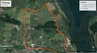
I went towards Wieck, where the river Ryck flows into the Baltic Sea and there is the Wiecker Brücke, an old Bascule Bridge made of wood; it is one of the two points where I can cross the river. After that, I rode along known paths through fields. I passed through Wampen and before going after the hash I stopped to search for another curious coordinate.
I went after an irrational coordinate (some side-hobby of mine). Every coordinate can be irrational, but I search for special ones. In this case, there is the point where the latitude has the same irrational part as π (.14159...) and the longitude the same irrational part as √2 (.41421...). We could consider them famous irrational numbers.
Well, I managed to reach those coordinates, and after the excitement of doing so, I went finally to search for the hash. As I saw home in OSM, there could be a path, but I was more focused on seeing if there where tractor tracks. The field on question, was a rapeseed field not yet harvested. Those rapeseed field look gorgeous on May when they bloom. Now they are already dry and look pale brown-ish.
Right where I wanted to enter the field was a car parked, but it didn't seem that there was someone near. Quite curious. Maybe there was someone in another field near, but I did see no one.
Here I started to follow the tracks so that I would not damage any plants. And more or less the distance kept going down. 300... 200... 100... slowly, because it was not easy walking though there, but decreasing steadily. Until the tracks turned 90º degrees as expected, and it looked right. 20.. 10.. 2m yes! I took some pictures as proof, screenshot, and hidden in the middle of the field I started the way back. It went faster, maybe because I made the path a bit broader. Once again in the road, still no one to see and grabbed my bike again, and biked towards Neuenkirchen, to go back to the other side. In Greifswald, center, there is the other bridge where I can cross the river to be again on my side.
Here I had only 15 minutes by bike until I was home again. Now, I can spent the afternoon with my duties ;) But today is already a successful day.
Tracklog
Photos
Achievements
SastRe.O earned the Land geohash achievement
|
SastRe.O with Winterbuche earned the Bicycle geohash achievement
|
Other Geohashing Expeditions and Plans on This Day
Expeditions and Plans
| 2019-07-09 | ||
|---|---|---|
| Braunschweig, Germany | GeorgDerReisende | The hash lay at a junction of a field way to the Gießereistraße near Salzgi... |
| Stralsund, Germany | SastRe.O | In a field north of Neuenkirchen, MV, Germany. |


