2020-02-22 42 -78
| Sat 22 Feb 2020 in 42,-78: 42.0671245, -78.6771753 geohashing.info google osm bing/os kml crox |
Contents
[hide]Location
Allegany State Park, near a Horse Trail by Thunder Rocks
Participants
- Pedalpusher
- Simon the dog
- Myka the dog
Expedition
I had pretty much given up hope that the Wiki was coming back, but I still checked the hashpoints every day using Eupeode's Geohashing.info site. The night before, I just happened to pull up the HashDroid app to review the hashpoints for the weekend while I thought about where to go hiking with the dogs. I knew from checking earlier at work that the hash was in Allegany again, but it was a couple KM away from the road and it likely wasn't worth exploring that area. However, it was at that moment that I saw the fantastic news: The app was updated and the update notes said the Wiki had moved! I didn't realize how much I missed our small community and reading about everyone's expeditions. I was so excited I had trouble falling asleep, but I knew where I was going hiking with the dogs the next day!
I did some cleaning around the house to feel at least a little productive and then made lunch and pizza dough for dinner later. Getting the dogs ready, we were out the door around 13:00. Reviewing the Allegany map and Open Streetmaps, I determined this Hash was close to and not too far down the steep ridges from the Horse Trail. I was shooting to get to the parking area around 14:30 to allow plenty of time to get to the hash for the Official Saturday Meetup.
Turns out, this trail is used for snowmobiles in the winter, but with not a lot of snow on the ground, there wasn't anyone out. The first section was pretty steep getting up to the top of the ridges in this section of Allegany, but once we were at the top, it was easy going. I figured I could walk for about 45 minutes before I would get close to the Hash and just enjoyed the hike. After some time, I flipped on my GPS to allow it to pick up the signal and figure out where on the trail was the closest spot. I was able to find I could get within about 300 meters on the trail but I was still about 45 minutes early for Hash O'clock. I decided to keep walking and set my alarm for 15 minutes. That would allow me enough time to get back here and then find the hash right on time.
I ended up walking a little longer after my alarm went off to turn around, but I still had plenty of time to get to the hash. I thought I would be able to get really close walking along the top of the ridge that jutted out from the trail, but it started to go down quickly. I kept following the GPS and eventually honed in on the spot. With a standard GPS Dance, I got a good reading and took some pictures. The path I took on the way down was pretty steep and I didn't want to go back that way. I was pretty sure the trail turned around me to the North so I walked parallel to the slope and worked my way slowly up it so the going was much easier. We got to a flat spot and I was nearly certain this was the shallow bowl area I had past on the trail heading out. A short while later, I popped out on the trail and was no longer 'sorta lost'.
We still had plenty of daylight left so I took a detour down another trail heading toward Thunder Rocks. Walking here for 15 or 20 minutes, we didn't get too far, but nicely extended our hike. We got to a pipeline that looked down the hill and I could almost see the parking area where the car was. I contemplated walking the more direct route, but decided against it and glad I did. Getting back to the car, I saw the area where I would have been walking and it looked kind of filled with enough brush and snow that the going would have been difficult.
Tired but very happy to officially be Geohashing again, we headed for home where I enjoyed homemade beer and pizza for dinner.
Photos
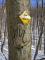
On the way up the trail, I found someone carved their handprint on a tree.

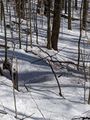
We walked past the hash and this is the way back, but the sun felt glorious and it was a perfect day for a hike.
I noticed some old fencing next to the trail and stopped to check out the sign. It says "Danger, Abandoned Oil Well. Risk of Falling".
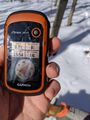
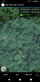
Made it exactly to the hash!
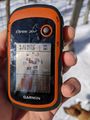
Accuracy.
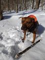
Myka hanging around with her stick at the hash.
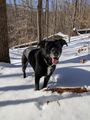
Simon is having a good time at the hash.
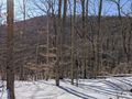
View West from the hash toward the next ridge over

Simon photobombing the Stupid Grin capture with one of his own.
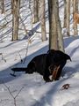
Working our way back to the trail, Simon would run ahead and then lay down in the snow to chew on his stick while we caught up.
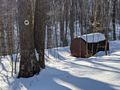
We passed this on the way out but I didn't know what it was. Finding the old Oil Well makes sense this was probably a holding tank.
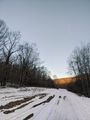
Almost back to the car, an evening shot looking back at the Horse trail we walked up.
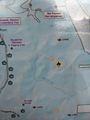
At the trailhead, a map of where we walked. We got a little past the Snowmobiler before turning around and the hash is on the ridge just behind and to the south of the horse.
Hash-droid screenshot for the Official Saturday meetup.


Ribbons
This user earned the Land geohash achievement
|
Pedalpusher earned the xkcd Viginturion achievement
|