2020-02-26 62 29
| Wed 26 Feb 2020 in 62,29: 62.7133225, 29.8550218 geohashing.info google osm bing/os kml crox |
Location
In a forest close to the Nurmeksentie road in Uuro, Kontiolahti.
Participants
Plans
On the 22nd or the 23rd of February, I happened to check if the geohashing wiki was still down, and to my surprise it was not. I had been only occasionally checking the situation since September and did not feel like doing expeditions if I could not report them in any worthwhile way. So now why not go to an expedition as soon as I get a good enough location? The hashpoints of the weekend were too inconvenient for me, so I had to wait. The point of this Wednesday was close enough, and the weather was perfect for outdoor activities: sunny and slightly freezing, about −5 °C. I could simply cycle along the road and walk a few tens of metres to the hashpoint.
Expedition
I left from work at about 5 o'clock and began cycling the 15-kilometre distance to the hashpoint. The sun was still up, but it would set within half an hour, and it would get dark within an hour or so. The road conditions were pretty much perfect for cycling, except for a four-kilometre stretch where I had to cycle on the roadway: the road surface consisted of some dry asphalt (very good grip) and some packed snow (good grip) with patches of smooth ice (extremely slippery) in between. I had to be very careful to not do any manoeuvres on the ice or I could slip and fall in an instant. I almost fell a few times, but nevertheless I eventually got to the hashpoint safely.
I parked my bicycle by the road and walked some 50 metres to the hashpoint. It was already almost 6 o'clock and dark enough that I could not get good photos with the camera. I could also feel that the temperature was decreasing quickly towards −10 °C, and my fingers began to go numb due to the coldness. I was wearing supposedly adequate clothing, but obviously having to handle the camera and the GPS receiver with bare hands did not help to keep them warm. Therefore I left quickly and tried to get home as soon as possible. (Of course, I could have done the most sensible thing and gone to the petrol station 200 metres away to warm up, but... well, I have no real excuse.) I stopped a few times to take photos of the moon and Venus which were shining on the southwestern sky. The distance to home was about twelve kilometres.
This was undoubtedly a Frozen Geohash. I could not record the temperature at the hashpoint, but the Finnish Meteorological Institute[1] reports a maximum temperature of −3.8 °C for the day in Joensuu (15 km away), and accuweather.com[2] reports a maximum temperature of −4 °C in Kontiolahti. I could feel that the temperature was close to −10 °C, but since it is nowhere enough to be a Cold Geohash, it does not matter much.
Photos
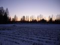
The last rays of the sun.
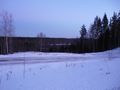
A view to the Pielisjoki river.
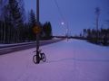
The bicycle parked on the side of the road. The streetlights had just turned on.
Hashpoint reached!
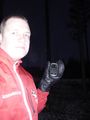
Me at the hashpoint, with flash.
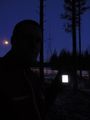
Me at the hashpoint, without flash.
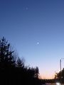
Picture of the moon and Venus on the sky.
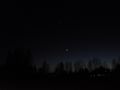
Another picture of the moon and Venus, same location as the first picture.


Achievements
Kripakko earned the Land geohash achievement
|
Kripakko earned the Bicycle geohash achievement
|
Kripakko earned the Frozen Geohash Achievement
|