2020-04-09 52 10
| Thu 9 Apr 2020 in Braunschweig: 52.3628478, 10.0732215 geohashing.info google osm bing/os kml crox |
Location
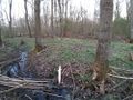
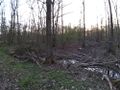
This Geohash is located next to a stream in a forest near Lehrte.
Participants
Expedition
After work, I took the bike to Lehrte via Bilm and Ilten. In Ilten, I wanted to check out if the location for tomorrow's Geohash was accessable, which it was not.
I continued towards the forest, which is called Hämeler Wald, and the adjactant settled part of Lehrte is also called Hämelerwald, but without the space. In the forest, I was able to get close to the coordinates on the main path, and even closer on a smaller, unmapped path. There also was a small stream which I crossed several times while trying and eventually succeeding to locate the coordinates. After recording proof, I left the forest again, riding towards the setting sun.
On the way back, I passed next Monday's geohash without realising it. It is okay though, I am planning to visit it on Monday anyway. I rode through Ahlten, which I have never visited during the day but now the third time after sunset while Geohashing, Anderten and eventually arrived back home.
Photos
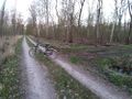
My bicycle near the Geohash
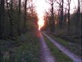
The sunset in the forest
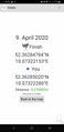
Proof
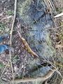
The Geohash
Surroundings
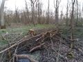
Surroundings
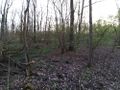
Surroundings
Surroundings
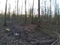
The site of the Geohash


Tracklog
Ribbons
Fippe earned the Land geohash achievement
|
Fippe earned the Bicycle geohash achievement
|
Fippe earned the Regional geohashing achievement
|