2020-04-18 42 -77
| Sat 18 Apr 2020 in 42,-77: 42.6826804, -77.9306422 geohashing.info google osm bing/os kml crox |
Contents
[hide]Location
Near the Fingerlakes trail in Letchworth, on the Eastern side of the river
Participants
- Pedalpusher
- Simon the dog
- Myka the dog
Expedition
I was planning on doing the Buffalo expedition first in the morning, but I wanted to make this an Official Saturday Meetup. To do that, I would need to leave the house around 11:45 to get to Letchworth around 13:00 (I wanted to put in ~3 hour hike before going to the hashpoint). I also wanted to make tomato sauce in the morning and that would eat up the time for the Buffalo expedition (which I fully expected to be posted anyway).
After making sauce and getting some Pizza dough ready for dinner later, I packed up the dogs and we were on our way to Letchworth. Pretty much taking Route 20A almost all the way out there, I didn't turn on my phone GPS until we got past Warsaw. Finding the road with the Fingerlakes trailhead access point, I parked the car and we started heading down.
The plan was to walk by the hash area to note where it was and then walk North on the trail for about an hour and a half before turning around and getting to the hash. However, the trail was not doing what I was expecting and did not cross under the Power Lines like I expected or saw in the OpenStreetMap view. I then hit a fork in the trail far earlier than I thought so I went to the left which was heading more in the direction of the Power Lines. I'm glad I did, because we eventually did hit the Power Lines but much closer to the river than I was expecting but I also found another wide trail heading back up along them. I suspected this was the trail I saw on the map and made a mental note to go that way on the way back.
Since I was already heading South on the Finger Lakes Trail, I just kept going. There were many ravines the path walked along and around and while the trees were still pretty bare from winter, it was a great hike. Right as my alarm went off to turn around, I got to a 'spur trail' that was leading toward the river. I decided to walk an extra 5 minutes anyway since the hash and path to it was closer than I had planned when I initially set my alarm. I'm glad I did, because at the end of the trail, was a nice (but narrow) vista looking out over the main canyon that gives Letchworth the nickname "Grand Canyon of the East".
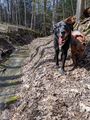
Heading back, I passed a family of 4 and we said hello as they passed by. Observing "Social Distancing" in the times of COVID-19, I stepped off the trail with the dogs so they could easily pass by without being close. The two young girls thought the dogs were very adorable. Getting back to the trail I was thinking that led to the hash, I started making my way up. Sure enough, we started to zig-zag under the Power Lines and this was definitely looking like where I initially expected to be. The path was very muddy with standing water in places but we managed to get to the zag closes to the hash and started into the woods. I was starting to get concerned with about 100 meters to go, because the woods were very thick with brush and sharp brambles. Fortunately, very close to the hash, the woods opened up and it was very easy to do a short GPS dance to get a good reading.
Making our way back to the path, we continued to the road and I found this was another trail but wasn't clearly marked and not too far down the road from the Finger Lakes Trail Access where I parked. I then headed for home. The drive home was uneventful, and we arrived around 18:00 which still gave me plenty of daylight. So I decided to go for the Buffalo Hash after all.
Photos
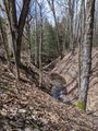
There were a lot of creeks the trail crossed and over the millennia they have carved some deep ravines.
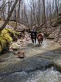
Where there's water, you'll find my dogs playing in it.
The vista where we turned around to head back to the hash.
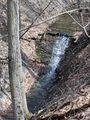
A small waterfall in one of the many creeks on the way back.
The dogs were starting to show some signs of being tired, but they are pretty happy too.
Finding the Hash.
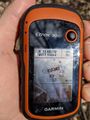
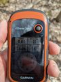
Accuracy.
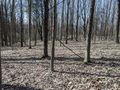
View West from the hash. In the hash area, it was very open.
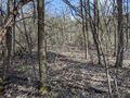
Looking back from where we came, things get thicker and harder to move through.
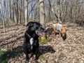
The dogs hanging out at the hash.

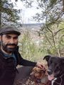
Standard Stupid Grin.

A few minutes late, but it's an Official Saturday Meetup.
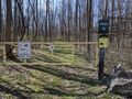
Getting back to the road, this turns out to be another access point for the Finger Lakes Trail.


Ribbons
This user earned the Land geohash achievement
|
Pedalpusher earned the Consecutive geohash achievement
|
Pedalpusher earned the xkcd Viginturion achievement
|