2020-08-17 48 7
| Mon 17 Aug 2020 in 48,7: 48.1359797, 7.3102063 geohashing.info google osm bing/os kml crox |
Location
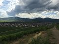
In a vineyard above Sigolsheim.
Participants
Expedition
I cycled to Ribeauvillé and took a small road, parallel to the Eurovelo 5, which goes over the hills, trough the vineyards and down to Kientzheim.
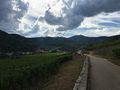
The coordinates were in a vineyard above the nearby town of Sigolsheim. From there, I had a nice view on the town and the Kaysersberg valley.
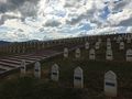
After reaching the geohash, I climbed to the military cemetery located on the top of the hill, just a few hundreds meters from there. It hosts the graves of French soldiers who died in the Battle of the Colmar Pocket during Winter 1944-45.
Then I went to Kaysersberg to have drink with a piece of blueberry pie and buy a postcard.
Photos
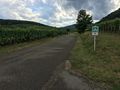
On the road from Riquewihr
Passing in Kientzheim
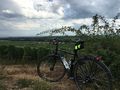
A few meters above the geohash
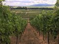
Strolling in the vineyard
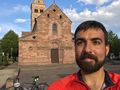
Coordinates reached

Stupid grin
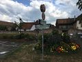
Sigolsheim
Sigolsheim National Cemetery
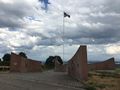
Memorial to fallen U.S. troops
Cycling to Kaysersberg
That would look nice on a postcard


Achievements
Baarde earned the Land geohash achievement
|
Baarde earned the Bicycle geohash achievement
|
Baarde earned the Two to the N achievement
|