2020-09-08 42 -78
| Tue 8 Sep 2020 in 42,-78: 42.1903642, -78.8293076 geohashing.info google osm bing/os kml crox |
Contents
[hide]Location
Bucktooth State Forest
Participants
- Pedalpusher
- Simon the dog
- Myka the dog
Expedition
I had a trip planned out at the beginning of the year to visit a friend in Australia at the end of September. Obviously, that's not going to be possible this year and suddenly I found myself with a lot of Time Off again that I need to use by the end of the year (unless work decides to extend carry-over rules like they did last year). Not wanting to hope for another rule change, I decided to take this week off to get some work done on the house and restart a stalled project on the upstairs hall.
After working most of the morning taking a section of wall down, I checked the hashpoints and was happy to see a fully accessible hash in a Public Forest. I would have to go off-trail into the woods but it didn't look too bad. I would be able to walk up a forest road most of the way and match the elevation before heading into the woods. That would definitely be easier than bushwacking up 500 feet/150 meters of elevation change in the woods.
After lunch, I lounged around the house for a bit relaxing and watching some TV (I am on vacation after all). Around 15:00, I realized I should probably get going if I wanted to get back early enough for a late dinner. I got things together and with the dogs in the car, we were on our way around 15:30. The hour drive was mostly uneventful and my phone GPS guided us to the gated forest road I wanted to walk up. I was able to park in front of the gate and pull off the road.
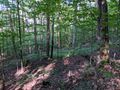
Starting up the road, I found it a pleasant walk as the road took a more meandering route than directly toward the hash. This made the incline a bit less steep than it could have been. Getting to the road split where I knew I would be closest to the hash, I headed into the woods. We only had to traverse a quarter mile/400 meters to find the hash. About halfway there, we found the Pine forest section I saw on the map which made for a nice change of scenery, even if it was just for a moment. Locating the Hash area, I started in on the GPS dance which took some time, but I was pleased to see I was able to get all 0's. After getting a bunch of pictures, we headed back to the road, and while I took a slightly different route, I came back out on the road exactly where I went in.
We still had plenty of daylight left, so I continued walking the road for a bit longer before turning around to head for home. Ended up walking for about an hour and a half in total, exploring this State Forest. I think I'll have to come back again as I saw on the map that the Finger Lakes Trail goes through here, but on the other side of the forest from where the hash was today.
Photos
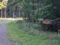
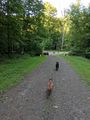
The Forest Road we walked up to get close to the hash.
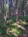
A grove of pine trees for a quick change of scenery.
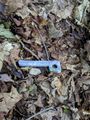
I have no idea what this is from, but it certainly doesn't belong in the woods. Removed and thrown out at home for a Geotrash event.
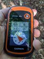
Perfect reading!
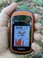
Accuracy.

I said an attention grabbing word and they perked right up for a good picture.
View East at the hash.
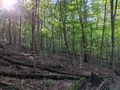
The woods were pretty uniform in this area, but a view West.

Standard Stupid Grin.
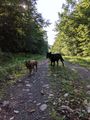
Walking the road after the hash.
Getting back to the Hash-Mobile after our hike.


Ribbons
This user earned the Land geohash achievement
|
Pedalpusher earned the GeoTrash Geohash Achievement
|